We are in the process of migrating all NASA Earth science data sites into Earthdata from now until end of 2026. Not all NASA Earth science data and resources will appear here until then. Thank you for your patience as we make this transition.
Read about the Web Unification Project
Earthquakes Data Access and Tools
From discovery to visualization, data tools such as GeoGateway, NASA Worldview, and Earthdata Search guide users in making the most of earthquake data.
Earthquakes Datasets
| Dataset Sort descending | Version | Platform | Instrument | Temporal Extent | Spatial Extent | Spatial Resolution | Data Format |
|---|---|---|---|---|---|---|---|
| Global Navigation Satellite System (GNSS) IGS Ultra-Rapid Combined Orbit Solution Product (sub-daily files, generated 4 times/day) from NASA CDDIS | 1 | Beidou, Galileo, GLONASS, GPS, GROUND STATIONS, QZSS, IRNSS, SBAS | Beidou P, Galileo P, GLONASS P, GPSP, GNSS, QZSS P, IRNSS P, SBAS P | 1992-01-01 to Present |
N: 90 S: -90 E: 180 W: -180 |
extended standard product-3 (SP3c) | |
| Global Navigation Satellite System (GNSS) IGS Ultra-Rapid Combined Orbit Solution Summary Product from NASA CDDIS | 1 | Beidou, Galileo, GLONASS, GPS, GROUND STATIONS, QZSS, IRNSS, SBAS | Beidou P, Galileo P, GLONASS P, GPSP, GNSS, QZSS P, IRNSS P, SBAS P | 1992-01-01 to Present |
N: 90 S: -90 E: 180 W: -180 |
Text format, UNIX compressed ASCII | |
| Global Navigation Satellite System (GNSS) IGS Ultra-Rapid Orbit Solution Comparison Summary Product from NASA CDDIS | 1 | Beidou, Galileo, GLONASS, GPS, GROUND STATIONS, QZSS, IRNSS, SBAS | Beidou P, Galileo P, GLONASS P, GPSP, GNSS, QZSS P, IRNSS P, SBAS P | 1992-01-01 to Present |
N: 90 S: -90 E: 180 W: -180 |
Text format, UNIX compressed ASCII | |
| Global Navigation Satellite System (GNSS) IGS Weekly Ionosphere Vertical Total Electron Content (VTEC) Grid Validation Product from NASA CDDIS | 1 | Beidou, Galileo, GLONASS, GPS, GROUND STATIONS, QZSS, IRNSS, SBAS | Beidou P, Galileo P, GLONASS P, GPSP, GNSS, QZSS P, IRNSS P, SBAS P | 1998-01-01 to Present |
N: 90 S: -90 E: 180 W: -180 |
IONEX (IONosphere map EXchange) | |
| GNSS GLONASS Combined Broadcast Ephemeris Data (30-second sampling, daily files) from NASA CDDIS | 1 | GLONASS, GROUND STATIONS | GLONASS P, GNSS | 1992-01-01 to Present |
N: 90 S: -90 E: 180 W: -180 |
RINEX | |
| Ground-Based Doppler Orbitography and Radiopositioning Integrated by Satellite (DORIS) Cumulative Station Position Product from NASA CDDIS | 1 | OSTM/JASON-2, GROUND STATIONS, CRYOSAT-2, Sentinel-3A, SARAL, HY2-A, JASON-3, ENVISAT, TOPEX/POSEIDON, JASON-1, SPOT-2, SPOT-3, SPOT-4, SPOT-5 | DORIS, DORIS GROUND STATION BEACON | 1992-01-01 to Present |
N: 90 S: -90 E: 180 W: -180 |
SINEX | |
| Ground-Based Doppler Orbitography and Radiopositioning Integrated by Satellite (DORIS) Extension of the International Terrestrial Reference Frame (ITRF) for Precise Orbit Determination (DPOD) from NASA CDDIS | 1 | OSTM/JASON-2, GROUND STATIONS, CRYOSAT-2, Sentinel-3A, SARAL, HY2-A, JASON-3, ENVISAT, TOPEX/POSEIDON, JASON-1, SPOT-2, SPOT-3, SPOT-4, SPOT-5 | DORIS, DORIS GROUND STATION BEACON | 1992-01-01 to Present |
N: 90 S: -90 E: 180 W: -180 |
IDS internal DPOD format | |
| Ground-Based Doppler Orbitography and Radiopositioning Integrated by Satellite (DORIS) IDS Coordinates of the Terrestrial Reference Frame (TRF) origin (Geocenter) Time Series Product from NASA CDDIS | 1 | OSTM/JASON-2, GROUND STATIONS, CRYOSAT-2, Sentinel-3A, SARAL, HY2-A, JASON-3, ENVISAT, TOPEX/POSEIDON, JASON-1, SPOT-2, SPOT-3, SPOT-4, SPOT-5, Sentinel-3B | DORIS, DORIS GROUND STATION BEACON | 1992-01-01 to Present |
N: 90 S: -90 E: 180 W: -180 |
Geocenter | |
| Ground-Based Doppler Orbitography and Radiopositioning Integrated by Satellite (DORIS) IDS Earth Orientation Parameters (EOP) Time Series Product from NASA CDDIS | 1 | GROUND-BASED OBSERVATIONS | DORIS | 1992-01-01 to Present |
N: 90 S: -90 E: 180 W: -180 |
EOP | |
| Ground-Based Doppler Orbitography and Radiopositioning Integrated by Satellite (DORIS) IDS Ionospheric Product from NASA CDDIS | 1 | GROUND STATIONS, ENVISAT, TOPEX/POSEIDON, JASON-1, SPOT-2, SPOT-4, SPOT-5, Sentinel-3B | DORIS GROUND STATION BEACON, DORIS | 1992-01-01 to Present |
N: 90 S: -90 E: 180 W: -180 |
SINEX | |
| Ground-Based Doppler Orbitography by Radiopositioning Integrated on Satellite (DORIS) Daily Data (raw files) from NASA CDDIS | 1 | OSTM/JASON-2, GROUND STATIONS, CRYOSAT-2, Sentinel-3A, SARAL, HY2-A, JASON-3 | DORIS, DORIS GROUND STATION BEACON | 1992-01-01 to Present |
N: 90 S: -90 E: 180 W: -180 |
RINEX DORIS 3.0 | |
| Ground-Based Doppler Orbitography by Radiopositioning Integrated on Satellite (DORIS) IDS Global SINEX Station Position Time Series Product from NASA CDDIS | 1 | OSTM/JASON-2, GROUND STATIONS, CRYOSAT-2, Sentinel-3A, SARAL, HY2-A, JASON-3, ENVISAT, TOPEX/POSEIDON, JASON-1, SPOT-2, SPOT-3, SPOT-4, SPOT-5 | DORIS, DORIS GROUND STATION BEACON | 1992-01-01 to Present |
N: 90 S: -90 E: 180 W: -180 |
IDS STCD (Station Coordinates Difference) format | |
| Ground-Based Doppler Orbitography by Radiopositioning Integrated on Satellite (DORIS) IDS Satellite Orbit Product from NASA CDDIS | 1 | OSTM/JASON-2, GROUND STATIONS, CRYOSAT-2, Sentinel-3A, SARAL, HY2-A, JASON-3, ENVISAT, TOPEX/POSEIDON, JASON-1, SPOT-2, SPOT-3, SPOT-4, SPOT-5, Sentinel-3B | DORIS, DORIS GROUND STATION BEACON | 1992-01-01 to Present |
N: 90 S: -90 E: 180 W: -180 |
SP1 or SP3 orbit format | |
| Ground-Based Doppler Orbitography by Radiopositioning Integrated on Satellite (DORIS) IDS Weekly Station Position Product from NASA CDDIS | 1 | OSTM/JASON-2, GROUND STATIONS, CRYOSAT-2, Sentinel-3A, SARAL, HY2-A, JASON-3, ENVISAT, TOPEX/POSEIDON, JASON-1, SPOT-2, SPOT-3, SPOT-4, SPOT-5 | DORIS, DORIS GROUND STATION BEACON | 1992-01-01 to Present |
N: 90 S: -90 E: 180 W: -180 |
SINEX | |
| Ground-Based Doppler Orbitography by Radiopositioning Integrated on Satellite (DORIS) Multi-Day Data (preprocessed files) from NASA CDDIS | 1 | JASON-1, OSTM/JASON-2, SPOT-2, SPOT-3, GROUND STATIONS, SPOT-4, SPOT-5, CRYOSAT-2, ENVISAT, TOPEX/POSEIDON, SARAL, HY2-A, Sentinel-3B | DORIS, DORIS GROUND STATION BEACON | 1992-01-01 to Present |
N: 90 S: -90 E: 180 W: -180 |
DORIS 2.2 | |
| Ground-Based Global Navigation Satellite System Combined Broadcast Ephemeris Data (daily files) from NASA CDDIS | 1 | Beidou, Galileo, GLONASS, GPS, GROUND STATIONS, QZSS, IRNSS, SBAS | Beidou P, Galileo P, GLONASS P, GPSP, GNSS RECEIVERS, QZSS P, IRNSS P, SBAS P | 1992-01-01 to Present |
N: 90 S: -90 E: 180 W: -180 |
RINEX | |
| Ground-Based Global Navigation Satellite System Data (30-second sampling, 1 hour files) from NASA CDDIS | 1 | Beidou, Galileo, GLONASS, GPS, GROUND STATIONS, QZSS, IRNSS | Beidou RECEIVERS, Galileo RECEIVERS, GLONASS RECEIVERS, GPS RECEIVERS, GNSS RECEIVER, QZSS RECEIVERS, IRNSS RECEIVERS | 2005-10-07 to Present |
N: 90 S: -90 E: 180 W: -180 |
RINEX | |
| Ground-Based Global Navigation Satellite System Data (30-second sampling, 24 hour files) from NASA CDDIS | 1 | Beidou, Galileo, GLONASS, GPS, GROUND STATIONS, QZSS, IRNSS | Beidou RECEIVERS, Galileo RECEIVERS, GLONASS RECEIVERS, GPS RECEIVERS, GNSS RECEIVER, QZSS RECEIVERS, IRNSS RECEIVERS | 1992-01-01 to Present |
N: 90 S: -90 E: 180 W: -180 |
||
| Ground-Based Global Navigation Satellite System GLONASS (GLObal NAvigation Satellite System) Summary Data (30-second sampling, daily files) from NASA CDDIS | 1 | GLONASS, GROUND STATIONS | GLONASS P, GNSS RECEIVER | 1998-01-01 to Present |
N: 90 S: -90 E: 180 W: -180 |
RINEX V2 | |
| Ground-Based Global Navigation Satellite System (GNSS) Beidou Broadcast Ephemeris Data (30-second sampling, hourly files) from NASA CDDIS | 1 | Beidou, GROUND STATIONS | Beidou P, GNSS | 1992-01-01 to Present |
N: 90 S: -90 E: 180 W: -180 |
RINEX | |
| Ground-Based Global Navigation Satellite System (GNSS) Beidou Broadcast Ephemeris Data (daily files) from NASA CDDIS | 1 | Beidou, GROUND STATIONS | Beidou P | 1992-01-01 to Present |
N: 90 S: -90 E: 180 W: -180 |
RINEX | |
| Ground-Based Global Navigation Satellite System (GNSS) Combined Broadcast Ephemeris Data (30-second sampling, hourly files) from NASA CDDIS | 1 | Beidou, Galileo, GLONASS, GPS, GROUND STATIONS, QZSS, IRNSS, SBAS | Beidou P, Galileo P, GLONASS P, GPSP, GNSS, QZSS P, IRNSS P, SBAS P | 1992-01-01 to Present |
N: 90 S: -90 E: 180 W: -180 |
RINEX | |
| Ground-Based Global Navigation Satellite System (GNSS) Compact Observation Data (30-second sampling, daily, 24 hour files) from NASA CDDIS | 1 | Beidou, Galileo, GLONASS, GPS, GROUND STATIONS, QZSS, IRNSS, SBAS | Beidou P, Galileo P, GLONASS P, GPSP, GNSS RECEIVER, QZSS P, IRNSS P, SBAS P | 1992-01-01 to Present |
N: 90 S: -90 E: 180 W: -180 |
compact RINEX | |
| Ground-Based Global Navigation Satellite System (GNSS) Data (1-second sampling, real-time streams) from NASA CDDIS | 1 | Beidou, Galileo, GLONASS, GPS, GROUND STATIONS, QZSS, IRNSS | Beidou P, Galileo P, GLONASS P, GPSP, GNSS RECEIVER, QZSS P, IRNSS P | 1992-01-01 to Present |
N: 90 S: -90 E: 180 W: -180 |
RTCM (Radio Technical Commission for Maritime Services) | |
| Ground-Based Global Navigation Satellite System (GNSS) Galileo Broadcast Ephemeris Data (30-second sampling, hourly files) from NASA CDDIS | 1 | Galileo, GROUND STATIONS | Galileo P, GNSS | 1992-01-01 to Present |
N: 90 S: -90 E: 180 W: -180 |
RINEX |
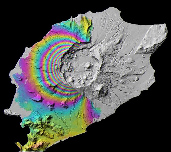
Featured Earthquakes Observation Method: Sentinel-1 C-SAR
The Synthetic Aperture Radar (SAR) aboard the ESA (European Space Agency's) Sentinel-1A/B satellites provides continuous all-weather, day-and-night land imagery. SAR images can be combined to produce interferograms, which are images showing changes in land height or position associated with earthquakes.
Join us Jan 25 at 2 p.m., ET [UTC -5], to learn how to use the Alaska Satellite Facility's OpenSARLab to work with synthetic aperture radar (SAR) data in the cloud.
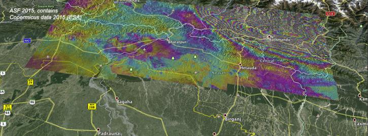
Ground deformation caused by the April 25 Nepal earthquake is clearly visible in this new interferogram processed from Sentinel-1A data by ASF DAAC scientists Franz Meyer and Wenyu Gong.

Explore and download data and imagery from EOSDIS for the the Nepalese region affected by the earthquake on April 25, 2015 and aftershocks.
2 MIN READ
Frequently Asked Questions
Earthdata Forum
Our online forum provides a space for users to browse thousands of FAQs about research needs, data, and data applications. You can also submit new questions for our experts to answer.
Submit Questions to Earthdata Forumand View Expert Responses