
Ocean Color Data Access and Tools

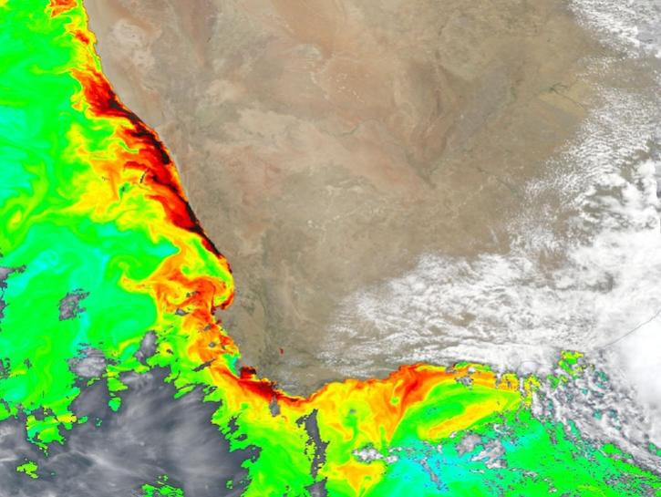
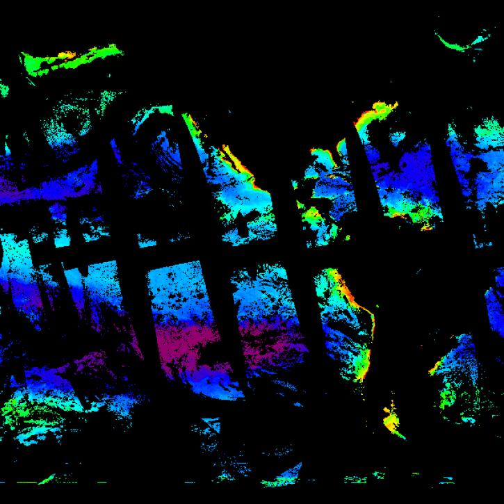
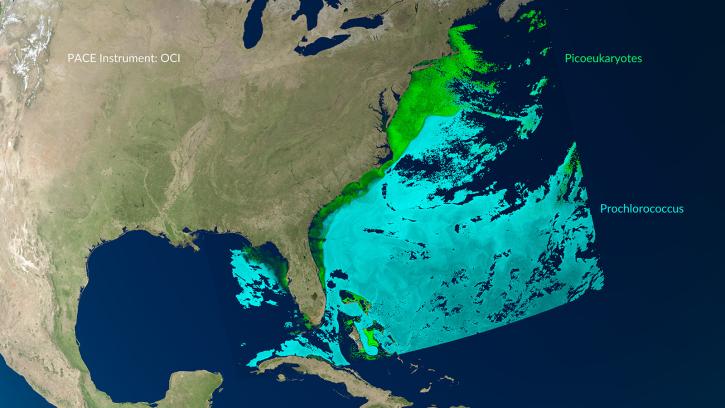
NASA has ocean color datasets that help researchers study the composition of ocean water and the processes that take place within it. Access a range of data and data tools such as AppEEARS, SeaDAS, and Giovanni to make the most of ocean color data.

Ocean Color Datasets

Filters
Dataset Sort descending Version Platform Instrument Temporal Extent Spatial Extent Spatial Resolution Data Format
ADEOS-I OCTS Level-2 Regional Ocean Color (OC) Data, version 2022.0 2022.0 ADEOS-I OCTS 1996-10-31 to 1997-06-30

N: 90 S: -90 E: 180 W: -180

netCDF-4
Aqua MODIS Level-2 Regional Ocean Color (OC) - Near Real-time (NRT) Data, version 2022.0 2022.0 Aqua MODIS 2002-07-04 to Present

N: 90 S: -90 E: 180 W: -180

netCDF-4
Aqua MODIS Level-2 Regional Ocean Color (OC) Data, version 2022.0 2022.0 Aqua MODIS 2002-07-04 to Present

N: 90 S: -90 E: 180 W: -180

netCDF-4
Aqua MODIS Level-4 Global Binned Apparent Visible Wavelength (AVW) Data, version 2022.0 2022.0 Aqua MODIS 2002-07-04 to Present

N: 90 S: -90 E: 180 W: -180

netCDF-4
Aqua MODIS Level-4 Global Mapped Apparent Visible Wavelength (AVW) Data, version 2022.0 2022.0 Aqua MODIS 2002-07-04 to Present

N: 90 S: -90 E: 180 W: -180

netCDF-4
CALIPSO CALIOP Regional Particulate Backscattering Coefficient (Bbp) Data, version 1 1 CALIPSO CALIOP 2006-04-28 to 2018-09-14

N: 90 S: -90 E: 180 W: -180

netCDF-4
COMS GOCI Level-2 Regional Ocean Color (OC) Data, version 2014.0 2014.0 COMS GOCI 2010-06-26 to 2021-03-31

N: 90 S: -90 E: 180 W: -180

netCDF-4
ENVISAT MERIS Level-1B Full Resolution, Full Swath (FRS) Data, version 4 4 ENVISAT MERIS 2002-03-21 to 2012-05-09

N: 90 S: -90 E: 180 W: -180

NetCDF
ENVISAT MERIS Level-1B Reduced Resolution (RR) Data, version 4 4 ENVISAT MERIS 2002-03-21 to 2012-05-09

N: 90 S: -90 E: 180 W: -180

NetCDF
ENVISAT MERIS Level-2 Regional Full Resolution, Full Swath (FRS) Ocean Color (OC) Data, version 2022.0 2022.0 ENVISAT MERIS 2002-03-21 to 2012-05-09

N: 90 S: -90 E: 180 W: -180

netCDF-4
ENVISAT MERIS Level-2 Regional Reduced Resolution (RR) Ocean Color (OC) Data, version 2022.0 2022.0 ENVISAT MERIS 2002-03-21 to 2012-05-09

N: 90 S: -90 E: 180 W: -180

netCDF-4
ENVISAT MERIS Level-4 Global Binned Apparent Visible Wavelength (AVW) Data, version 2022.0 2022.0 ENVISAT MERIS 2002-03-21 to 2012-05-09

N: 90 S: -90 E: 180 W: -180

netCDF-4
ENVISAT MERIS Level-4 Global Mapped Apparent Visible Wavelength (AVW) Data, version 2022.0 2022.0 ENVISAT MERIS 2002-03-21 to 2012-05-09

N: 90 S: -90 E: 180 W: -180

netCDF-4
Full Resolution Full Swath Geolocated and Calibrated TOA Radiance 4 ENVISAT MERIS 2002-05-17 to 2012-04-08

N: 90 S: -90 E: 180 W: -180

netCDF-4
Full Resolution Full Swath Geophysical Product for Ocean, Land and Atmosphere 4 ENVISAT MERIS 2003-01-01 to 2012-04-08

N: 90 S: -90 E: 180 W: -180

netCDF4-zipped
ISS HICO Level-0 Raw Science Data, version 1 1 ISS HICO 2009-09-25 to 2014-09-13

N: 90 S: -90 E: 180 W: -180

binary
ISS HICO Level-1B Data, version 2 2 ISS HICO 2009-09-25 to 2014-09-13

N: 90 S: -90 E: 180 W: -180

netCDF-4
ISS HICO Level-2 Regional Ocean Color (OC) Data, version 2018.0 2018.0 ISS HICO 2009-09-25 to 2014-09-13

N: 90 S: -90 E: 180 W: -180

netCDF-4
NASA Ocean Biogeochemical Model assimilating satellite chlorophyll data global daily VR2017 (NOBM_DAY) at GES DISC R2017 NOBM NOT APPLICABLE 1998-01-01 to 2015-12-31

N: 72 S: -84 E: 180 W: -180

1.25 Decimal Degrees x 0.67 Decimal Degrees
NASA Ocean Biogeochemical Model assimilating satellite chlorophyll data global monthly VR2017 (NOBM_MON) at GES DISC R2017 NOBM NOT APPLICABLE 1998-01-01 to 2015-12-31

N: 72 S: -84 E: 180 W: -180

1.25 Decimal Degrees x 0.67 Decimal Degrees
Nimbus-7 CZCS Level-2 Regional Ocean Color (OC) Data, version 2022.0 2022.0 Nimbus-7 CZCS 1978-10-30 to 1986-06-22

N: 90 S: -90 E: 180 W: -180

netCDF-4
NOAA-20 VIIRS Level-2 Regional Ocean Color (OC) - Near Real-time (NRT) Data, version 2022.0 2022.0 NOAA-20 VIIRS 2017-11-29 to Present

N: 90 S: -90 E: 180 W: -180

netCDF-4
NOAA-20 VIIRS Level-2 Regional Ocean Color (OC) Data, version 2022.0 2022.0 NOAA-20 VIIRS 2017-11-29 to Present

N: 90 S: -90 E: 180 W: -180

netCDF-4
NOAA-20 VIIRS Level-4 Global Binned Apparent Visible Wavelength (AVW) Data, version 2022.0 2022.0 NOAA-20 VIIRS 2017-11-29 to Present

N: 90 S: -90 E: 180 W: -180

netCDF-4
NOAA-20 VIIRS Level-4 Global Mapped Apparent Visible Wavelength (AVW) Data, version 2022.0 2022.0 NOAA-20 VIIRS 2017-11-29 to Present

N: 90 S: -90 E: 180 W: -180

netCDF-4

Ocean Color Data Tools

Tool Sort descending Description Services
Ocean Color Level 3 and 4 Browser The Ocean Color Level 3 and 4 Browser allows users to view, download, or order global composites at various spatial and temporal scales (level 3) or get results from analyses of lower-level data (level 4). Analysis, Search and Discovery, Visualization
SeaDAS Sea, earth, atmosphere Data Analysis System (SeaDAS) is a comprehensive image analysis package for the processing, display, analysis, and quality control of ocean color data. Analysis, Visualization, Processing
SHOWING 2 OF 2

Frequently Asked Questions

Earthdata Forum

Our online forum provides a space for users to browse thousands of FAQs about research needs, data, and data applications. You can also submit new questions for our experts to answer.

Submit Questions to Earthdata Forumand View Expert Responses

Earthdata
Forum