We are in the process of migrating all NASA Earth science data sites into Earthdata from now until end of 2026. Not all NASA Earth science data and resources will appear here until then. Thank you for your patience as we make this transition.
Read about the Web Unification Project
Terra Resources
Documents
| Name Sort descending | Description | File Type | Date Published | |
|---|---|---|---|---|
| MISR Level 3 Component Products Quality Statement | his statement applies to the MISR Level 3 Georectified Radiance product, MISR Level 3 Aerosol product, the MISR Level 3 Land Surface product, the MISR Level 3 Albedo product, and the MISR Level 3 Cloud product with a production date of December 1, 2005, or later until such a time as further improvements to MISR software or ancillary inputs are made. |
PDF (205.97 kb) | Dec. 1, 2005 | |
| MISR Level 3 Joint Aerosol Product Quality Statement | This statement applies to the MISR Level 3 Joint Aerosol (JOINT_AS) product (versions F01_0001 and later). | PDF (67.78 kb) | Oct. 15, 2012 | |
| MISR Level 3 Land Surface and Aerosol Versioning | Product information about MISR Level 3 Land Surface and Aerosol Versioning. | PDF (581.61 kb) | July 25, 2024 | |
| MISR Quality Statements Full Range | Covers full range of MISR products, describes broader organizational structure across four product groups. | PDF (55.6 kb) | Sept. 30, 2014 | |
| MISR Quality Statements Newer | Information on MISR Level 2 and Level 3 products released starting in 2012 | PDF (60.05 kb) | Sept. 30, 2014 |
SHOWING 5 OF 60
Terra Learning Resources

This ARSET training provides an overview of NASA resources for monitoring climate change and its impacts.
Training
Sept. 29 - Oct. 6, 2021

Esta capacitación de ARSET cubre similitudes y diferencias entre MODIS y VIIRS para monitoreo de calidad del agua.
Training
Sept. 14-21, 2021
This ARSET training provides an overview of the similarities and differences between MODIS and VIIRS for water quality monitoring.
Training
Sept. 14-21, 2021

This ARSET training provides an overview of species distribution models and how to use remote sensing data for landscape characterization.
Training
Aug. 12-19, 2021

Read highlights of three publications that detail how NASA Earth observation data informs earthquake prediction, the effects of wildfires on vegetation, and the impact of agriculture on African birds.
Data in Action
July 19, 2021

LANCE near real-time products enable the management of ongoing events; standard data products are heavily processed and intended for scientific research.
Data Basics
July 15, 2021

NASA DEVELOP participants used satellite data to identify priority areas for heat relief in Tempe, Arizona, creating tools to guide city officials in implementing targeted mitigation strategies.
Data in Action
June 29, 2021

This ARSET training covers the Google Earth Engine Code Editor and hands-on exercises for processes integral to optical imagery analysis.
Training
June 16-30, 2021
SHOWING 8 OF 231
Terra News
View All News
Filters

A summary of datasets, products, and resources released by NASA’s Distributed Active Archive Centers (DAACs) in March 2024.
News
April 3, 2024

The Geostationary Earth Orbit (GEO) – Low-Earth Orbit (LEO) Dark Target Aerosol product suite enables users to track rapid changes and movements in smoke and dust plumes that can severely impact air quality.
News
March 19, 2024
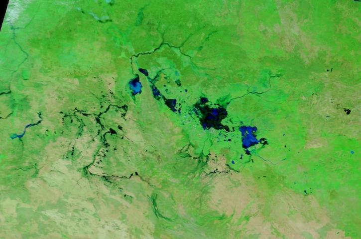
Image captured March 13, 2024, by the MODIS instrument aboard NASA's Terra satellite.
Worldview Image of the Week
March 14, 2024

A summary of datasets, products, and resources released by NASA’s Distributed Active Archive Centers (DAACs) in Feb 2024.
News
March 4, 2024
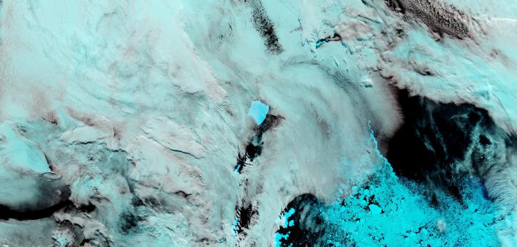
Image captured on February 27, 2024, by the MODIS instrument aboard NASA's Terra satellite.
Worldview Image of the Week
Feb. 29, 2024

The View Data tool lets users find and preview full-resolution MODIS and VIIRS atmospheric datasets prior to downloading.
Feature Article
Feb. 23, 2024

NASA researchers are tweaking algorithms and combining data from multiple satellites to track tropical forest fires in Brazil.
Feature Article
Feb. 1, 2024
A summary of datasets, products, and resources released by NASA’s Distributed Active Archive Centers (DAACs) in November 2023.
News
Dec. 5, 2023
SHOWING 8 OF 449
Frequently Asked Questions
Earthdata Forum
Our online forum provides a space for users to browse thousands of FAQs about research needs, data, and data applications. You can also submit new questions for our experts to answer.
Submit Questions to Earthdata Forumand View Expert Responses