We are in the process of migrating all NASA Earth science data sites into Earthdata from now until end of 2026. Not all NASA Earth science data and resources will appear here until then. Thank you for your patience as we make this transition.
Read about the Web Unification Project
Sentinel-1 Resources
Earthdata resources for users working with NASA’s Sentinel-1 data include tutorials and other learning resources, news announcements such as instrument updates and data releases, user guides and related documents, and frequently asked questions.
Sentinel-1 Learning Resources
This presentation demonstrates how to process Sentinel-1 Interferometric Synthetic Aperture Radar (InSAR) GAMMA SBAS time series using HyP3.
Webinar
Jan. 24, 2024
In this video, Rudi Gens provides an introduction to NASA’s Observational Products for End-Users from Remote Sensing Analysis (OPERA) project data product suite.
Webinar
Jan. 23, 2024

Access cloud-optimized Sentinel-1 radiometric terrain corrected synthetic aperture radar (SAR) backscatter products from NASA's Observational Products for End-Users from Remote Sensing Analysis (OPERA) project.
Tutorial
Dec. 1, 2023
Access cloud-optimized Sentinel-1 radiometric terrain corrected synthetic aperture radar (SAR) backscatter products from NASA's Observational Products for End-Users from Remote Sensing Analysis (OPERA) project.
StoryMap
Dec. 1, 2023

Esta capacitación amplía la teoría y aplicaciones de datos SAR para detectar y monitorear inundaciones usando series temporales de SAR.
Training
Oct. 24 - Nov. 1, 2023
This training expands on the theory and applications of SAR data to detect and monitor floods using SAR time-series.
Training
Oct. 24 - Nov. 1, 2023

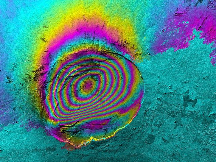
Sentinel-1 Single Look Complex (SLC) products include three sub-swaths, each containing many individual burst SLCs. Working at the burst level provides several key benefits.
Tutorial
June 14, 2023

Work with Sentinel-1 Burst products from NASA’s Alaska Satellite Facility Distributed Active Archive Center (ASF DAAC).
StoryMap
June 14, 2023
SHOWING 8 OF 65
Sentinel-1 News
View All News
Filters
Remote sensing data help researchers measure change in the Alaskan landscape.
Data User Story
April 17, 2022

NASA's ASF DAAC released the Global Seasonal Sentinel-1 Interferometric Coherence and Backscatter Dataset.
News
March 11, 2022

NASA’s Land, Atmosphere Near real-time Capability for EOS (LANCE) helps scientists like Dr. Glasscoe assess risks and responses to natural hazards on a global scale.
Data User Story
Dec. 8, 2021

Synthetic Aperture Radar (SAR) Data from NASA’s ASF DAAC helps scientists like Dr. Steve Bowman provide Utah’s citizens with timely scientific information about the state’s geologic hazards.
Data User Story
June 29, 2021

Talking about Synthetic Aperture Radar (SAR) with Dr. Franz Meyer, Chief Scientist, Alaska Satellite Facility (ASF)
Data User Story
May 12, 2021

Who uses NASA Earth science data? Dr. Xiaofeng Li, to study atmospheric and oceanic processes.
Data User Story
April 22, 2021

For the people of Asia and Southeast Asia, water is integral to their livelihood. Dr. Hossain uses NASA Earth observing data to improve water management and accelerate economic development in these regions.
Data User Story
April 22, 2021
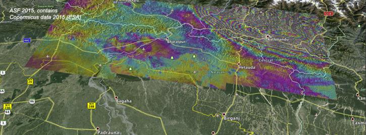
Ground deformation caused by the April 25 Nepal earthquake is clearly visible in this new interferogram processed from Sentinel-1A data by ASF DAAC scientists Franz Meyer and Wenyu Gong.
News
March 30, 2021
SHOWING 8 OF 44
Frequently Asked Questions
Earthdata Forum
Our online forum provides a space for users to browse thousands of FAQs about research needs, data, and data applications. You can also submit new questions for our experts to answer.
Submit Questions to Earthdata Forumand View Expert Responses