We are in the process of migrating all NASA Earth science data sites into Earthdata from now until end of 2026. Not all NASA Earth science data and resources will appear here until then. Thank you for your patience as we make this transition.Read about the Web Unification Project
Description
The AST14DEM Version 3 data product was decommissioned on December 15, 2025. Users are encouraged to use the AST14DEM Version 4 data product.
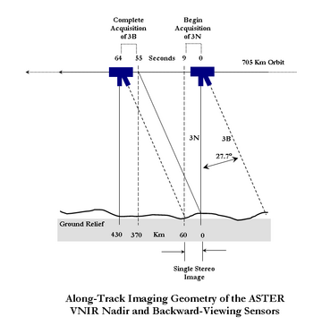
The Terra Advanced Spaceborne Thermal Emission and Reflection Radiometer (ASTER) Digital Elevation Model (AST14DEM) product is generated using bands 3N (nadir-viewing) and 3B (backward-viewing) of an ASTER Level 1A image acquired by the Visible and Near Infrared (VNIR) sensor. The VNIR subsystem includes two independent telescope assemblies that facilitate the generation of stereoscopic data. The band 3 stereo pair is acquired in the spectral range of 0.78 and 0.86 microns with a base-to-height ratio of 0.6 and an intersection angle of 27.7 degrees. There is a time lag of approximately one minute between the acquisition of the nadir and backward images.For a better understanding, refer to the ASTER Along Track Imaging Geometry diagram depicting the along-track imaging geometry of the ASTER VNIR nadir and backward-viewing sensors.
The accuracy of the new LP DAAC produced DEMs will meet or exceed accuracy specifications set for the ASTER relative DEMs by the Algorithm Theoretical Basis Document (ATBD). Users likely will find that the DEMs produced by the new LP DAAC system have accuracies approaching those specified in the ATBD for absolute DEMs. Validation testing has shown that DEMs produced by the new system frequently are more accurate than 25 meters root mean square error (RMSE) in xyz dimensions.
The ASTER Digital Elevation Model data product is only available through NASA's Earthdata Search. The ASTER Order Instructions provide step-by-step directions for ordering this product.
Known Issues
Data acquisition gaps: On November 28, 2024, one of Terra's power-transmitting shunt units failed. As a result, there was insufficient power to maintain functionality of the ASTER instrument. ASTER resumed acquisitions for the VNIR bands on January 18, 2025, and for the TIR bands on April 15, 2025. Users should note the data gap in ASTER acquisitions from November 28, 2024, through January 16, 2025, for VNIR observations, and a gap from November 28, 2024, through April 15, 2025, for TIR acquisitions.
Improvements/Changes from Previous Versions
Starting June 23, 2021, radiometric calibration coefficient Version 5 (RCC V5) will be applied to newly observed ASTER data and archived ASTER data products. Details regarding RCC V5 are described in the following journal article.
Tsuchida, S., Yamamoto, H., Kouyama, T., Obata, K., Sakuma, F., Tachikawa, T., Kamei, A., Arai, K., Czapla-Myers, J.S., Biggar, S.F., and Thome, K.J., 2020, Radiometric Degradation Curves for the ASTER VNIR Processing Using Vicarious and Lunar Calibrations: Remote Sensing, v. 12, no. 3, at https://doi.org/10.3390/rs12030427.
As of January 2021, the LP DAAC has implemented version 3.0 of the Sensor Information Laboratory Corporation ASTER DEM/Ortho (SILCAST) software, which is used to generate the Level 2 on-demand ASTER Orthorectified and Digital Elevation Model (DEM) products (AST14). The updated software provides digital elevation extraction and orthorectification from ASTER L1A input data without needing to enter ground control points or depending on external global DEMs at 30-arc-second resolution (GTOPO30). It utilizes the ephemeris and attitude data derived from both the ASTER instrument and the Terra spacecraft platform. The outputs are geoid height-corrected and waterbodies are automatically detected in this version. Users will notice differences between AST14DEM, AST14DMO, and AST14OTH products ordered before January 2021 (generated with SILCAST V1) and those generated with the updated version of the production software (version 3.0). Differences may include slight elevation changes over different surface types, including waterbodies. Differences have also been observed over cloudy portions of ASTER scenes. Additional information on SILCAST version 3.0 can be found on the SILCAST website.
Version Description
The following changes and improvements were implemented for ASTER Version 3 data products: (1) Geometric correction to account for Earth's rotation angle and nutation, (2) Geometric correction for geolocation errors associated with nighttime TIR scenes, and (3) Radiometric correction to account for degradation of onboard calibration lamps.
Land Processes Distributed Active Archive Center (LP DAAC)
,
Ground Data System, Japan Space Systems, National Institute of Advanced Industrial Science and Technology, Ministry of Economy, Trade, and Industry, Japan (JP/METI/AIST/JSS/GDS)
Citation is critically important for dataset documentation and discovery. This dataset is openly shared, without restriction, in accordance with the EOSDIS Data Use and Citation Guidance.
Copy Citation
Citation Copied
NASA/METI/AIST/Japan Spacesystems and U.S./Japan ASTER Science Team. (2001). ASTER DEM Product [Dataset]. NASA Land Processes Distributed Active Archive Center. https://doi.org/10.5067/ASTER/AST14DEM.003 Date Accessed: 2026-07-31
NASA/METI/AIST/Japan Spacesystems and U.S./Japan ASTER Science Team. (2001). ASTER DEM Product [Dataset]. NASA Land Processes Distributed Active Archive Center. https://doi.org/10.5067/ASTER/AST14DEM.003 Date Accessed: 2026-07-31
NASA/METI/AIST/Japan Spacesystems and U.S./Japan ASTER Science Team. “ASTER DEM Product.” NASA Land Processes Distributed Active Archive Center, 2001, https://doi.org/10.5067/ASTER/AST14DEM.003. Date Accessed: 2026-07-31
The file name begins with the Product Short Name (AST14DEM), followed by the 3-digit Version Number plus the Date and Time of Acquisition designated as MMDDYYYYHHMMSS (0030913202523064), Date and Time of Processing designated as YYYYMMDDHHMMSS (2025091514524), Unique Processing Identifier (839325), and the Data Format (tif).
Devenish, Christian, Junaid, Achmad Ridha, Andriansyah, Saryanthi, Ria, van Balen, S. (Bas), Kaprawi, Fajar, Aprianto, Ganjar Cahyo, Stanley, Richard C., Poole, Oliver, Owen, Andrew, Collar, N. J., Marsden, Stuart J.
The table below lists the variables contained within a single granule for this
dataset. Variables often contain observed or derived geophysical measurements
collected from a variety of sources, including remote sensing instruments on
satellite and airborne platforms, field campaigns, in situ measurements, and
model outputs. The terms variable, parameter, scientific data set, layer, and band
have been used across NASA’s Earth science disciplines; however, variable is the
designated nomenclature in NASA’s Common Metadata Repository (CMR).
Variable metadata attributes such as Name, Description, Units, Data Type, Fill
Value, Valid Range, and Scale Factor allow users to efficiently process and analyze
the data. The full range of attributes may not be applicable to all variables.
Additional information on variable attributes is typically available in the data,
user guide, and/or other product documentation.
For questions on a specific variable, please use the Earthdata Forum.