NASA has ocean winds datasets that help researchers characterize the flow of air moving across the ocean. Access a range of data and data tools such as AppEEARS, Worldview, and Giovanni to make the most of ocean winds data.
Ocean Winds Data Access and Tools
Ocean Winds Datasets
| Dataset Sort descending | Version | Platform | Instrument | Temporal Extent | Spatial Extent | Spatial Resolution | Data Format |
|---|---|---|---|---|---|---|---|
| Sentinel-1A Single Polarization High Resolution Ground Range Detected Product | 1 | Sentinel-1A | C-SAR | 2014-04-03 to Present |
N: 90 S: -90 E: 180 W: -180 |
||
| Sentinel-1A Single Polarization High Resolution Ground Range Detected Product Metadata | 1 | Sentinel-1A | C-SAR | 2014-04-03 to Present |
N: 90 S: -90 E: 180 W: -180 |
||
| Sentinel-1A Single Polarization Medium Resolution Ground Range Detected Product | 1 | Sentinel-1A | C-SAR | 2014-04-03 to Present |
N: 90 S: -90 E: 180 W: -180 |
||
| Sentinel-1A Single Polarization Medium Resolution Ground Range Detected Product Metadata | 1 | Sentinel-1A | C-SAR | 2014-04-03 to Present |
N: 90 S: -90 E: 180 W: -180 |
||
| Sentinel-1B Dual Polarization High Resolution Ground Range Detected Product | 1 | Sentinel-1B | C-SAR | 2016-04-25 to 2021-12-24 |
N: 90 S: -90 E: 180 W: -180 |
||
| Sentinel-1B Dual Polarization High Resolution Ground Range Detected Product Metadata | 1 | Sentinel-1B | C-SAR | 2016-04-25 to 2021-12-24 |
N: 90 S: -90 E: 180 W: -180 |
||
| Sentinel-1B Dual Polarization Medium Resolution Ground Range Detected Product | 1 | Sentinel-1B | C-SAR | 2016-04-25 to 2021-12-24 |
N: 90 S: -90 E: 180 W: -180 |
||
| Sentinel-1B Dual Polarization Medium Resolution Ground Range Detected Product Metadata | 1 | Sentinel-1B | C-SAR | 2016-04-25 to 2021-12-24 |
N: 90 S: -90 E: 180 W: -180 |
||
| Sentinel-1B Level 0 Product | 1 | Sentinel-1B | C-SAR | 2016-04-25 to 2021-12-24 |
N: 90 S: -90 E: 180 W: -180 |
||
| Sentinel-1B Level 0 Product Metadata | 1 | Sentinel-1B | C-SAR | 2016-04-25 to 2021-12-24 |
N: 90 S: -90 E: 180 W: -180 |
||
| Sentinel-1B Ocean Product | 1 | Sentinel-1B | C-SAR | 2016-04-25 to 2021-12-24 |
N: 90 S: -90 E: 180 W: -180 |
||
| Sentinel-1B Ocean Product Metadata | 1 | Sentinel-1B | C-SAR | 2016-04-25 to 2021-12-24 |
N: 90 S: -90 E: 180 W: -180 |
||
| Sentinel-1B Single Look Complex Product | 1 | Sentinel-1B | C-SAR | 2016-04-25 to 2021-12-24 |
N: 90 S: -90 E: 180 W: -180 |
||
| Sentinel-1B Single Look Complex Product Metadata | 1 | Sentinel-1B | C-SAR | 2016-04-25 to 2021-12-24 |
N: 90 S: -90 E: 180 W: -180 |
||
| Sentinel-1B Single Polarization High Resolution Ground Range Detected Product | 1 | Sentinel-1B | C-SAR | 2016-04-25 to 2021-12-24 |
N: 90 S: -90 E: 180 W: -180 |
||
| Sentinel-1B Single Polarization High Resolution Ground Range Detected Product Metadata | 1 | Sentinel-1B | C-SAR | 2016-04-25 to 2021-12-24 |
N: 90 S: -90 E: 180 W: -180 |
||
| Sentinel-1B Single Polarization Medium Resolution Ground Range Detected Product | 1 | Sentinel-1B | C-SAR | 2016-04-25 to 2021-12-24 |
N: 90 S: -90 E: 180 W: -180 |
||
| Sentinel-1B Single Polarization Medium Resolution Ground Range Detected Product Metadata | 1 | Sentinel-1B | C-SAR | 2016-04-25 to 2021-12-24 |
N: 90 S: -90 E: 180 W: -180 |
||
| Sentinel-1C Ocean Product | 1 | Sentinel-1C | C-SAR | 2025-03-28 to Present |
N: 90 S: -90 E: 180 W: -180 |
SAFE | |
| Sentinel-1C Ocean Product Metadata | 1 | Sentinel-1C | C-SAR | 2025-03-28 to Present |
N: 90 S: -90 E: 180 W: -180 |
XML | |
| Sentinel-1D Ocean Product | 1 | Sentinel-1D | C-SAR | 2026-04-15 to Present |
N: 90 S: -90 E: 180 W: -180 |
SAFE | |
| Sentinel-1D Ocean Product Metadata | 1 | Sentinel-1D | C-SAR | 2026-04-15 to Present |
N: 90 S: -90 E: 180 W: -180 |
XML | |
| SMMR/Nimbus-7 Color Images V001 (SMMRN7IM) | 001 | Nimbus-7 | SMMR | 1978-10-30 to 1983-11-02 |
N: 90 S: -90 E: 180 W: -180 |
25 Kilometers x 25 Kilometers | |
| S-MODE L2 Shipboard Meteorological Data from Rawinsondes Version 1 | 1 | Ships | RAWINSONDES, RADIOSONDES | 2021-10-21 to 2023-05-31 |
N: 38.1 S: 36.3 E: -122.9 W: -125.4 |
netCDF-4 | |
| SMODE L2 WAVEGLIDERS TEMP SALINITY V1 | 1 | Wave Glider | CTD, ADCP, MMS, CURRENT METERS | 2021-10-28 to 2023-05-14 |
N: 38.2 S: 36.3 E: -122.1 W: -126.2 |
netCDF-4 |
Featured Ocean Winds Observation Method: S-MODE
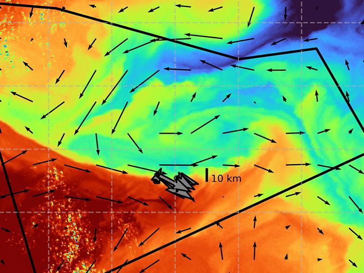
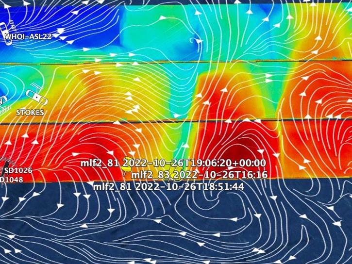
The Sub-Mesoscale Ocean Dynamics Experiment (S-MODE) was a NASA campaign studying small-scale ocean eddies and fronts. S-MODE consisted of three deployments off the coast of San Francisco during the fall of 2021-2022 and spring of 2023. Airborne measurements were taken with different remote instruments including the Doppler Scatterometry (DopplerScatt), Multiscale Observing System of the Ocean Surface (MOSES), Modular Aerial Sensing System (MASS), and Portable Remote Imaging SpectroMeter (PRISM). In-situ measurements were obtained through research vessels, gliders, drifters, and other water-based platforms.
Get Help
QUESTIONS & SUPPORT
Get help with NASA Earth science data, datasets, tools, services, and metadata on the Earthdata Forum. Experienced staff in the data user community review and answer questions.
Get help on Earthdata ForumForum