We are in the process of migrating all NASA Earth science data sites into Earthdata from now until end of 2026. Not all NASA Earth science data and resources will appear here until then. Thank you for your patience as we make this transition.
Read about the Web Unification Project
Tropical Cyclones News
Articles, resources, and announcements from Tropical Cyclones.

Data overlays from Worldview show precipitation rates and sea surface temperatures in mid-April 2026, as the storm moved across the western Pacific.
Worldview Image of the Week
April 17, 2026

The VIIRS instrument aboard the NOAA-20 platform captured this image on March 26, 2026.
Worldview Image of the Week
March 27, 2026

Image captured September 24, 2025, by the VIIRS instrument aboard the joint NASA/NOAA NOAA-21 platform.
Worldview Image of the Week
Sept. 25, 2025

Giovanni and Panoply are dynamic data tools that enable users to create a plot of data values in a data map and produce related visualizations.
News
Aug. 19, 2025

This image was captured on July 30, 2025, by the VIIRS instrument aboard the joint NASA/NOAA NOAA-21 platform.
Worldview Image of the Week
July 31, 2025
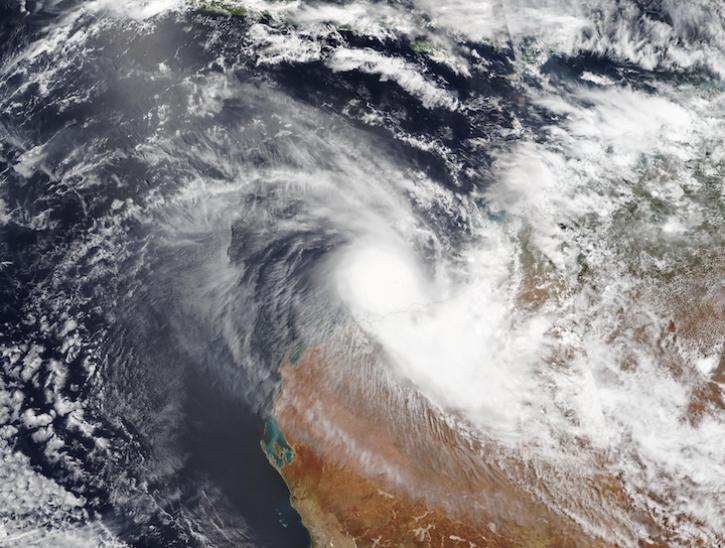
Image captured on Feb 13, 2025, by the VIIRS instrument aboard the joint NASA/NOAA NOAA-20 platform.
Worldview Image of the Week
Feb. 13, 2025

The Compact Ocean Wind Vector Radiometer (COWVR) and Temporal Experiment for Storms and Tropical Systems (TEMPEST) datasets are the first from the Space Test Program - Houston 8 (STP-H8) mission that aims to test low-cost, light-weight instruments designed for weather applications.
News
Jan. 17, 2025
Join us on January 29 at 2PM ET (-05:00 UTC) to learn how to access and use MERRA-2, GPM, TROPICS, and LDAS data provided by NASA's Goddard Earth Sciences Data and Information Services Center (GES DISC) to investigate Hurricane Milton's milestones.
Webinar
Jan. 10, 2025
SHOWING 8 OF 154