We are in the process of migrating all NASA Earth science data sites into Earthdata from now until end of 2026. Not all NASA Earth science data and resources will appear here until then. Thank you for your patience as we make this transition.
Read about the Web Unification Project
Filters

View the agenda and access presentation slides from the NASA Ocean Biology and Biogeochemistry Group 2021 meeting.
Event
Oct. 27, 2021
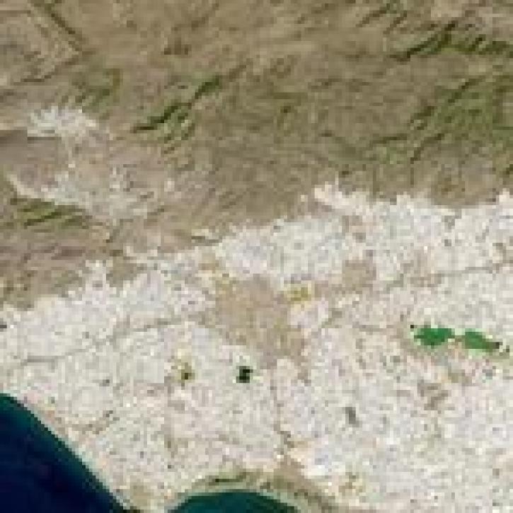
Image captured on 18 September 2021 by the OLI instrument aboard the Landsat 8 satellite.
Worldview Image of the Week
Oct. 25, 2021

Expertise and skill of new ESDIS hires will help the project manage the growth of EOSDIS data collections and enhance users’ experience.
Feature Article
Oct. 25, 2021
Data from NASA’s GES DISC helps scientists like Dr. Nadia Smith build and improve retrieval systems that provide important information to climate scientists and meteorologists around the globe.
Data User Story
Oct. 25, 2021

Satellites provide crucial information for researchers to monitor and help improve agricultural productivity in India.
Feature Article
Oct. 22, 2021

Image captured on Aug 22, 2021, by the VIIRS instrument, aboard the joint NASA/NOAA NOAA 20 satellite.
Worldview Image of the Week
Oct. 22, 2021

The policy provides specific guidance for ensuring that all SMD-funded research is fully and openly available.
Feature Article
Oct. 22, 2021
My NASA Data uses NASA Earth observing data to improve data literacy for students in grades 3-12.
Feature Article
Oct. 21, 2021
SHOWING 8 OF 2379