We are in the process of migrating all NASA Earth science data sites into Earthdata from now until end of 2026. Not all NASA Earth science data and resources will appear here until then. Thank you for your patience as we make this transition.
Read about the Web Unification Project
Filters

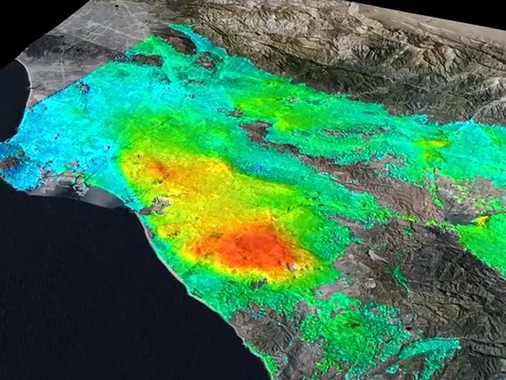
Base image acquired Sep 27, 2023, by the VIIRS instrument aboard the joint NASA/NOAA Suomi NPP satellite and overlaid with Aerosol Index values from the OMPS instrument.
Worldview Image of the Week
Sept. 28, 2023

Salinity data from NASA’s Physical Oceanography Distributed Active Archive Center (PO.DAAC) help Dr. Frederick Bingham study ocean dynamics.
Data User Story
Sept. 28, 2023

Join NASA's Prediction Of Worldwide Energy Resources (POWER) Project October 11-12 for the second virtual Global Community (GloCo) Summit. Learn about the Project’s latest enhancements, help drive future improvements, and engage with keynote speakers from the POWER community.
Event
Sept. 27, 2023

A recent workshop brought together experts from NASA, Oak Ridge National Laboratory (ORNL), IBM Research, NVIDIA, and several universities to develop a plan to create an artificial intelligence foundation model (AI FM) for weather and climate.
News
Sept. 26, 2023

Dr. Rahul Ramachandran, senior research scientist and project manager of NASA’s Interagency Implementation and Advanced Concepts Team (IMPACT), is being honored by the American Geophysical Union (AGU) for his numerous data innovations.
News
Sept. 22, 2023

Image captured on Sep 22, 2023, by the ABI instrument aboard the GOES-East satellite.
Worldview Image of the Week
Sept. 22, 2023
Learn about the data formats and tools you'll need to work with NASA/Indian Space Research Organization (ISRO) SAR (NISAR) data.
Webinar
Sept. 19, 2023
A NASA-funded project is creating a cloud-based radio occultation data archive for atmospheric researchers.
Feature Article
Sept. 18, 2023
SHOWING 8 OF 2379