We are in the process of migrating all NASA Earth science data sites into Earthdata from now until end of 2026. Not all NASA Earth science data and resources will appear here until then. Thank you for your patience as we make this transition.
Read about the Web Unification Project
Filters

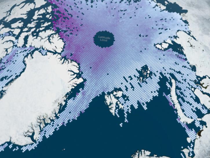
Image captured on Jul 4, 2022 by the VIIRS instrument aboard the NOAA-20 satellite.
Worldview Image of the Week
July 6, 2022
NSIDC DAAC's participation in the Forum gives users the chance to communicate with and learn from DAAC experts.
News
July 1, 2022

Find EOSDIS dataset and data tool news, top stories, links to webinars and tutorials and other learning resources, Data Chats, and Data User Profiles.
News
July 1, 2022

A new Combined Aqua and Terra MODIS Cloud Properties product is available at NASA's LAADS DAAC for both daily and monthly datasets.
News
June 30, 2022

Data from NASA’s SEDAC help Thomas Parris assess the impact of water stress on agriculture, industries, and people around the globe.
Data User Story
June 30, 2022

Image captured on Jun 27, 2022, by the MODIS instrument aboard the Terra satellite.
Worldview Image of the Week
June 28, 2022

New data layer lets users cut through the smoke to see surface features like active fire fronts and post-fire impacts.
Feature Article
June 24, 2022

Spire data will be openly available to U.S. government-funded researchers and federal agencies through NASA’s CSDA program.
Feature Article
June 24, 2022
SHOWING 8 OF 2379