We are in the process of migrating all NASA Earth science data sites into Earthdata from now until end of 2026. Not all NASA Earth science data and resources will appear here until then. Thank you for your patience as we make this transition.
Read about the Web Unification Project
Filters

NASA’s global precipitation data and data processing systems have come a long way from the launch of TRMM in 1997 to the ongoing GPM mission.
Feature Article
Nov. 4, 2020
NASA's data policy ensures that all NASA data are available fully, openly, and without restrictions. Here's what this means for you.
Feature Article
Nov. 4, 2020
The Common Metadata Repository (CMR) and Earthdata Search are now running in the cloud, which is the start of a new era for users of EOSDIS data and services.
Feature Article
Nov. 4, 2020

An Earthdata Login is all that’s needed to download data from the huge EOSDIS archive.
Feature Article
Nov. 4, 2020

The latest enhancements to the AppEEARS program provide access to more datasets along with greater flexibility for working with Earth observing data from NASA and other federal data archives.
Feature Article
Nov. 4, 2020
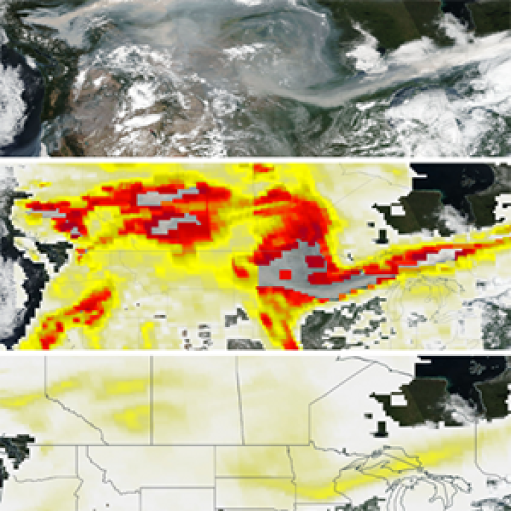
The new PyroCumuloNimbus product for the Ozone Mapping and Profiler Suite (OMPS) makes it easier to track and analyze high concentrations of aerosols from wildfires and similar events.
Feature Article
Nov. 4, 2020

The effort by multiple DAACs to develop the Earthdata Drive application is another example of how EOSDIS DAACs collaboratively create enterprise-wide solutions to improve the data user experience.
Feature Article
Nov. 4, 2020

After being in storage for more than 40 years, data recovered from NASA's Nimbus I, II, and III missions are extending the polar sea ice record back to the 1960s and giving scientists new views of this changing environment.
Feature Article
Nov. 4, 2020
SHOWING 8 OF 534