ALOS PALSAR land data
ALOS PALSAR ground receiver
ALOS PALSAR data

ALOS PALSAR RTC Project

Alaska Satellite Facility's Radiometric Terrain Correction Project

The objective of the Alaska Satellite Facility (ASF) ALOS PALSAR RTC Project was to generate an analysis-ready synthetic aperture radar (SAR) product suitable for use in a variety of Earth science applications. Radiometric terrain correction (RTC) removes the inherent geometric and radiometric distortions from an image caused by side-looking radar. Processing of the Advanced Land Observing Satellite (ALOS) Phased Array type L-band Synthetic Aperture Radar (PALSAR) RTC products began in October 2014 and was completed one year later. 

Data used in the RTC project were all ALOS PALSAR Fine Beam (FBS, FBD) and Polarimetric (PLR) scenes in the ASF archive at the time. Spatial coverage of the RTC products includes global land areas except those where a suitable digital elevation model (DEM) was not available – Antarctica, Greenland, Iceland, and northern Eurasia. 

Products are available in high-resolution (12.5-meter) and low-resolution (30-meter), are geocoded to a Universal Transverse Mercator (UTM) projection, and provided in an analysis-ready, Geographic Information Systems (GIS)-compatible GeoTIFF format.

Data Centers

ASF DAAC

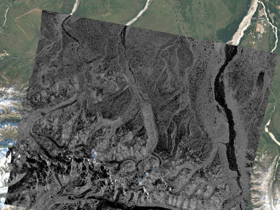
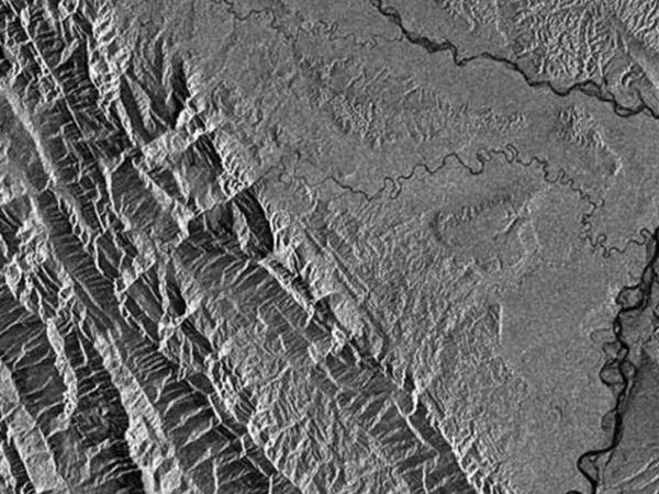
ALOS PALSAR RTC Project Overview

Property
High Resolution (RT1) Product
Low Resolution (RT2) Product
Temporal coverage2006-20112006-2011
Spatial coverageGlobalGlobal
Pixel spacing12.5 meter30 meter
File formatGeoTIFFGeoTIFF
Browse image format (size)GeoJPEG (1000 x 1000 px)GeoJPEG (1000 x 1000 px)
Pixel valuesGamma nought power in 32-bit floating point formatGamma nought power in 32-bit floating point format
Files included in the package
  • Incidence Angle GeoTIFF
  • Layover/Shadow GeoTIFF
  • Browse image GeoJPEG
  • KMZ
  • XML metadata
  • Modified DEM
  • Incidence Angle GeoTIFF
  • Layover/Shadow GeoTIFF
  • Browse image GeoJPEG
  • KMZ
  • XML metadata
  • Modified DEM
ProviderJapan Aerospace Exploration Agency (JAXA)Japan Aerospace Exploration Agency (JAXA)
Year published20142014
Citation (Example)ASF DAAC. (2014). ALOS PALSAR High Resolution Radiometric Terrain Corrected Product. NASA Alaska Satellite Facility Distributed Active Archive Center. https://doi.org/10.5067/Z97HFCNKR6VA Date Accessed: YYYY-MM-DDASF DAAC. (2014). ALOS PALSAR Low Resolution Radiometric Terrain Corrected Product. NASA Alaska Satellite Facility Distributed Active Archive Center. https://doi.org/10.5067/JBYK3J6HFSVF Date Accessed: YYYY-MM-DD

ALOS PALSAR RTC Product Files

File Type
Description
RTC GeoTIFF (.tif)
  • One file for each polarization
  • Pixel values are gamma nought power in 32-bit floating point format
  • 12.5-m pixel spacing for high-resolution (RT1); 30-m for low-resolution (RT2)
Incidence Angle GeoTIFF (.tif)
  • Identifies the angle in radians for each pixel
  • Pixel spacing the same as the RTC GeoTIFF
Layover/Shadow GeoTIFF (.tif)
  • Identifies where processing was impacted by layover or shadow
  • Pixel spacing the same as the RTC GeoTIFF
Modified DEM GeoTIFF (.tif)
  • Best resolution SRTM or NED source DEM available
  • Geoid correction applied
  • Pixel spacing the same as RTC GeoTIFF
Browse image GeoJPEG (.geo.jpg)
  • 1000 x 1000 pixels
  • Color images available for FBD and PLR beam modes
Metadata (.xml)
  • ISO 19115 format
KMZ (.kmz)
  • 30-m overlay

PALSAR RTC DEM Information and Disclaimer


The Digital Elevation Model (DEM) file included with the ALOS PALSAR Terrain Corrected product is not generated from PALSAR data. It is a copy of an existing DEM that has been modified and used for the radiometric terrain correction process. The pixel spacing of the source DEM was adjusted to match that of the Terrain Corrected image it is packaged with, and does not indicate the DEM’s resolution.

The source DEMs used for the ALOS PALSAR Terrain Corrected products are from either the Shuttle Radar Topography Mission (SRTM) or the National Elevation Dataset (NED). Refer to the table and map in the section About the source DEMs used for ALOS PALSAR RTC processing to determine the native resolution and spatial coverage of the source DEMs used for the project.

The source-DEM tiles covering the spatial extent of an uncorrected PALSAR scene were downloaded and mosaicked into a single DEM raster. This mosaicked DEM was processed to apply a geoid correction (see Fig. 1) and then resampled to match the output pixel spacing of the PALSAR scene.

The DEM files packaged with the RTC products are intended solely for reference in evaluating the radiometric terrain correction process. They should not be used in place of a regular DEM, as the geoid correction in preparation for RTC processing alters the elevation values.

Image
Image Caption

Figure 1. Most DEMs are geoid-based and require a conversion before they can be used for terrain correction. The DEM included with an ASF RTC product was converted from the orthometric height of the source DEM to ellipsoid height using the ASF MapReady geoid_adjust tool. This tool applies a geoid correction so that the resulting DEM relates to the ellipsoid. The GeoidEval Utility is a free online tool that computes the geoid height above the WGS84 ellipsoid at a specific location and shows the correction applied to the source DEM used to create an RTC product.

About the source DEMs used for ALOS PALSAR RTC processing

Image
Image Caption

Figure 2. Map showing the DEM used in the ALOS PALSAR RTC Project for different global regions.

The quality of an ALOS PALSAR RTC product is directly related to the quality of the digital elevation model (DEM) used in the radiometric terrain correction (RTC) process. The map (Fig. 2) indicates which DEM was used in a given location, and the table below summarizes the various DEM sources.

The continental U.S. (CONUS), Hawaii, and parts of Alaska are covered with a 1⁄3 arc-second National Elevation Dataset (NED) at a 10 m resolution. The rest of Alaska, above 60 degrees north latitude, was only available at 60 m resolution with two-arc-second NED data. One arc-second NED provided the best resolution for Canada and Mexico at a 30-meter scale. The Shuttle Radar Topography Mission (SRTM) GL1 data at one arc-second (30 m) resolution were used for the remaining globe. Greenland and Antarctica, which are mostly covered by ice and glaciers, were not terrain- or radiometrically corrected. No suitable DEMs were available for areas in Eurasia north of 60 degrees latitude.

ASF pre-processed the DEMs to a consistent raster format (GeoTIFF) from the source formats: height (*.hgt), ESRI ArcGrid (*.adf), etc. Many NASA-provided DEMs were provided as orthometric heights with the EGM96 vertical datum. These were converted to ellipsoid heights using the ASF MapReady tool named geoid_adjust. The pixel reference varied from the center (pixel as a point) to a corner (pixel as an area). The GAMMA software, used to generate the terrain-corrected products, uses pixels as an area and adjusts DEM coordinates as needed. When multiple DEMs were available, the highest-resolution DEM was processed. Complete DEM coverage from a single DEM source was a requirement for processing to proceed.

DEMs used for ALOS PALSAR RTC processing

DEM NameDatumSpatial CoverageDEM Resolution
NED13NAVD88CONUS, Hawaii, parts of Alaska~10m (1/3 arc sec)
SRTMGL1EGM96Latitudes between 60 N and 57 S degrees~30 m (1 arc sec)
SRTMUS1EGM96CONUS, Hawaii, parts of Alaska~30 m (1 arc sec)
NED1NAVD88CONUS, Hawaii, parts of Alaska, Canada, Mexico~30 m (1 arc sec)
NED2NAVD88Alaska~60 m (2 arc sec)

ALOS PALSAR RTC Technical Documents