We are in the process of migrating all NASA Earth science data sites into Earthdata from now until end of 2026. Not all NASA Earth science data and resources will appear here until then. Thank you for your patience as we make this transition.
Read about the Web Unification Project
MODIS Resources
Earthdata resources for users working with NASA’s Moderate Resolution Imaging Spectroradiometer (MODIS) data include tutorials and other learning resources, news announcements such as instrument updates and data releases, user guides and related documents, and frequently asked questions.
MODIS Learning Resources

NASA DEVELOP participants used satellite data to identify priority areas for heat relief in Tempe, Arizona, creating tools to guide city officials in implementing targeted mitigation strategies.
Data in Action
June 29, 2021

This ARSET training covers the Google Earth Engine Code Editor and hands-on exercises for processes integral to optical imagery analysis.
Training
June 16-30, 2021

This ARSET training introduces how NASA earth observations can contribute to a greater understanding of energy management applications.
Training
June 1-22, 2021

Join us to learn how to use NASA’s Worldview, an imagery mapping and visualization tool that provides access to over 900 data imagery layers, many of which are available within hours, even minutes, to explore Earth’s interconnected processes and events.
Webinar
May 26, 2021
NASA Earth science data are a key component in meeting the 17 Sustainable Development Goals (SDGs) to build a better world for people and our planet.
Data Basics
May 18, 2021

Esta capacitación de ARSET cubre el uso de observaciones terrestres para el monitoreo operativo de incendios.
Training
May 11-27, 2021
This ARSET training provides lectures and case studies focused on the use of Earth observations for operational fire monitoring.
Training
May 11-27, 2021

Satellite data reveals the oceanic response to the record-setting season.
Data in Action
March 25, 2021
SHOWING 8 OF 222

Global and US/Canada active Fire Maps enable users to visualize the location, extent, and impact of wildfires with minimal delay.
Feature Article
June 24, 2024
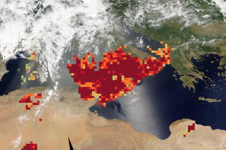
Image captured on June 20, 2024, by the MODIS and AIRS instruments aboard NASA's Aqua satellite.
Worldview Image of the Week
June 20, 2024

Data from NASA's Fire Information for Resource Management System (FIRMS) help personnel in Canada's Northwest Territories Department of Environment and Climate Change manage wildfires.
Feature Article
June 11, 2024

GHRSST Sea Surface Temperature image showing the Gulf Stream in the Atlantic Ocean on May 29, 2024.
Worldview Image of the Week
May 30, 2024
SHOWING 4 OF 526
Frequently Asked Questions
Earthdata Forum
Our online forum provides a space for users to browse thousands of FAQs about research needs, data, and data applications. You can also submit new questions for our experts to answer.
Submit Questions to Earthdata Forumand View Expert Responses