We are in the process of migrating all NASA Earth science data sites into Earthdata from now until end of 2026. Not all NASA Earth science data and resources will appear here until then. Thank you for your patience as we make this transition.
Read about the Web Unification Project
KaRIn Resources
Read the latest Ka-band Radar Interferometer (KaRIn) news and access learning resources designed to help you optimize your Earth science research.
KaRIn Learning Resources

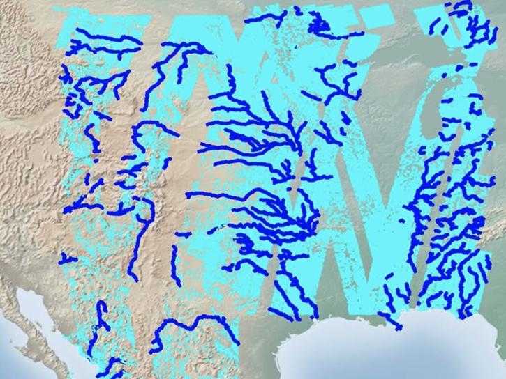
The SWOT Rivers Feature Service is available in both the ArcGIS REST Endpoints and Open Geospatial Consortium (OGC) Endpoints.
External Resource
GitHub Repository
March 29, 2023
Follow this step-by-step tutorial to upload data into popular and versatile Geographic Information Systems (GIS) programs.
Tutorial
Nov. 17, 2025

Researchers explore using SWOT data to derive two-dimensional estimates of sea ice thickness.
Data in Action
Nov. 13, 2025

Join us on Wed., July 30 at 2:00 p.m. EDT (-04:00 UTC) to explore SWOT hydrology data collections of rivers and lakes, and to learn how to work with SWOT hydrology data using tools provided by both NASA's PO.DAAC and the USGS.
Webinar
July 18, 2025
Esta capacitación se enfocará en introducir los datos de agua dulce del satélite SWOT y sus aplicaciones.
Training
May 13-16, 2025
This ARSET training focuses on introducing SWOT freshwater data products and their applications for water resources and disaster management.
Training
May 13-15, 2025

SWOT presents opportunities and challenges in characterizing sea surface height anomalies.
Data in Action
March 14, 2024

Learn how to discover, access, and use Surface Water and Ocean Topography (SWOT) mission data and how these data can lead to new, innovative science and applications in the world of water.
Webinar
March 6, 2024
SHOWING 8 OF 13

A summary of datasets, products, and resources released by NASA’s Distributed Active Archive Centers (DAACs) in December 2023.
News
Jan. 4, 2024

View a recording of the PO.DAAC open office hour that discusses the Surface Water and Ocean Topography (SWOT) data release.
News
Dec. 11, 2023
AppEEARS allows users to subset data spatially, temporally, and by layer, reducing the amount of data they need to download.
Feature Article
April 3, 2023
Careful calibration and validation ensure that the Surface Water and Ocean Topography mission will provide the best data possible.
Feature Article
March 17, 2023
SHOWING 4 OF 27
Frequently Asked Questions
Earthdata Forum
Our online forum provides a space for users to browse thousands of FAQs about research needs, data, and data applications. You can also submit new questions for our experts to answer.
Submit Questions to Earthdata Forumand View Expert Responses