We are in the process of migrating all NASA Earth science data sites into Earthdata from now until end of 2026. Not all NASA Earth science data and resources will appear here until then. Thank you for your patience as we make this transition.Read about the Web Unification Project
Description
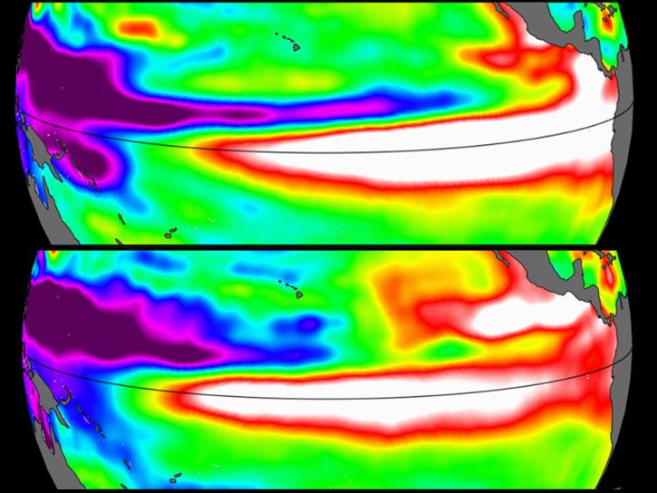
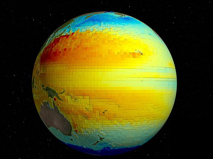
This dataset provides gridded Sea Surface Height Anomalies (SSHA) above a mean sea surface, on a 1/6th degree grid every 5 days. It contains the fully corrected heights, with a delay of up to 3 months. The gridded data are derived from the along-track SSHA data of TOPEX/Poseidon, Jason-1, Jason-2, Jason-3 and Jason-CS (Sentinel-6) as reference data from the level 2 along-track data found at https://podaac.jpl.nasa.gov/dataset/MERGED_TP_J1_OSTM_OST_CYCLES_V51, plus ERS-1, ERS-2, Envisat, SARAL-AltiKa, CryoSat-2, Sentinel-3A, Sentinel-3B, depending on the date, from the RADS database. The date given in the grid files is the center of the 5-day window. The grids were produced from altimeter data using Kriging interpolation, which gives best linear prediction based upon prior knowledge of covariance.
Citation is critically important for dataset documentation and discovery. This dataset is openly shared, without restriction, in accordance with the EOSDIS Data Use and Citation Guidance.
Copy Citation
Citation Copied
MEaSUREs. (2022). MEaSUREs Gridded Sea Surface Height Anomalies Version 2205 [Dataset]. NASA Physical Oceanography Distributed Active Archive Center. https://doi.org/10.5067/SLREF-CDRV3 Date Accessed: 2026-07-28
MEaSUREs. (2022). MEaSUREs Gridded Sea Surface Height Anomalies Version 2205 [Dataset]. NASA Physical Oceanography Distributed Active Archive Center. https://doi.org/10.5067/SLREF-CDRV3 Date Accessed: 2026-07-28
MEaSUREs. “MEaSUREs Gridded Sea Surface Height Anomalies Version 2205.” NASA Physical Oceanography Distributed Active Archive Center, 2022, https://doi.org/10.5067/SLREF-CDRV3. Date Accessed: 2026-07-28
Sea surface height data from the Sentinel-6 Michael Freilich mission reveal complex interactions between the ocean and the atmosphere that affect global weather and climate such as El Niño.
Karnauskas, Kristopher B., Nerem, R. Steven, Fasullo, John T., BellasManley, Ashley, Thompson, Philip R., Coats, Sloan, Chambers, Don P., Hamlington, Benjamin D.
The table below lists the variables contained within a single granule for this
dataset. Variables often contain observed or derived geophysical measurements
collected from a variety of sources, including remote sensing instruments on
satellite and airborne platforms, field campaigns, in situ measurements, and
model outputs. The terms variable, parameter, scientific data set, layer, and band
have been used across NASA’s Earth science disciplines; however, variable is the
designated nomenclature in NASA’s Common Metadata Repository (CMR).
Variable metadata attributes such as Name, Description, Units, Data Type, Fill
Value, Valid Range, and Scale Factor allow users to efficiently process and analyze
the data. The full range of attributes may not be applicable to all variables.
Additional information on variable attributes is typically available in the data,
user guide, and/or other product documentation.
For questions on a specific variable, please use the Earthdata Forum.