What are trace gases?
Trace gases are a diverse group of gases that collectively account for less than 1% of Earth's atmospheric volume. Despite their relative scarcity, these gases have a large impact on air quality, human health, and the planet’s heat balance. These include compounds like methane (CH4), ozone (O3), and chlorofluorocarbons (CFC).
Ozone at ground level can cause respiratory issues, but at higher altitudes it is an important part of Earth’s atmosphere, helping to shield the surface from harmful ultraviolet radiation. Methane is a potent contributor to Earth’s greenhouse gas effect. CFCs, which were used in commercial products like spray cans and refrigerants, reacted with ozone in the atmosphere, thinning out the stratospheric ozone layer and increasing exposure to ultraviolet radiation.
There are many other trace gas species that shape air quality and climate. Nitrogen dioxide (NO2), produced from burning of fossil fuels, can aggravate respiratory conditions. Carbon monoxide (CO), another byproduct of fuel use, can cause flu-like symptoms if inhaled. Nitrogen-based compounds in the atmosphere can cause acid rain, which can harm species in freshwater systems like lakes and rivers.
How do scientists monitor trace gases?
NASA has been monitoring trace gases in the atmosphere since 1975. Each of these chemical compounds has a unique signature of absorption in the electromagnetic spectrum. By measuring the atmosphere’s signal in these wavelengths, scientists can extrapolate the composition of gases in the air.
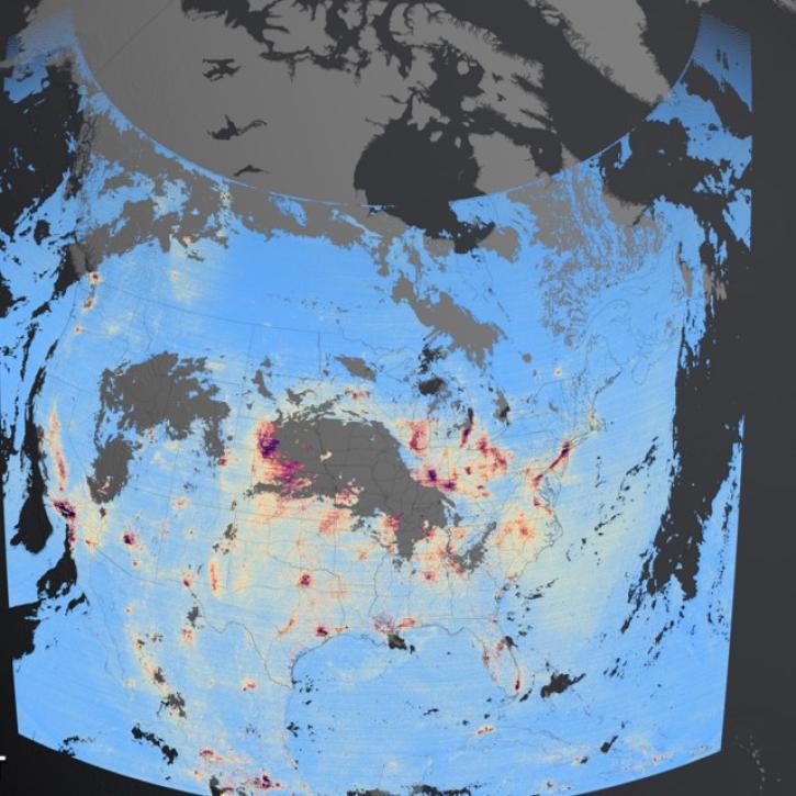
NASA’s Tropospheric Emissions: Monitoring of Pollution (TEMPO) instrument and the Tropospheric Monitoring Instrument (TROPOMI) aboard ESA’s Sentinel-5P spacecraft observe daily trace gas concentrations. TEMPO focuses on North America with visible and ultraviolet observations, while TROPOMI provides global observations in ultraviolet and shortwave infrared. Together, these missions provide continuous monitoring of many important trace gases species, including sulfur dioxide, nitrogen dioxide, ozone, and carbon monoxide.
Other missions focus instead on Earth’s ozone layer and its role in climate regulation. The Ozone Monitoring Instrument (OMI), built by the Netherlands and Finland and hosted on NASA’s Aura satellite, uses cloud pressure measurements to monitor ozone levels in the atmosphere. OMI also provides near real-time observations of other gases like nitrogen dioxide and sulfur dioxide. The Tropospheric Ozone Lidar Network (TOLNet) – a collaborative project between NOAA, NASA, and ESA – synthesizes observations from seven different lidar instruments to provide high-resolution tropospheric ozone datasets.
NASA also uses ground-based and airborne sensors to monitor trace gases. The Aerosol Robotic Network (AERONET) is a global network of ground-based sensors that collectively monitor aerosol and gas levels across 95% of Earth’s surface with a temporal resolution of 15 minutes.
What can scientists do with trace gas data?
NASA’s suite of satellite and ground sensors provide a detailed look at atmospheric trace gases. By observing across wavelengths, these instruments provide vertical profiles of trace gas concentrations at different altitudes. Daily datasets also help researchers identify how these gases fluctuate in response to changing climate and weather patterns, and to disturbances like wildfires.
These data also support atmospheric models related to climate and weather across decades. Monitoring of ozone and CFCs, for example, has helped researchers track the thinning and then recovery of the ozone layer.
Public health experts can monitor trace gas levels to identify periods of poor air quality that could impact respiratory health in vulnerable populations. The Air Quality Index (AQI), the standard measure of air quality in the United Staes, is based on measurements of pollutants include trace gases such as carbon monoxide and nitrogen dioxide.