We are in the process of migrating all NASA Earth science data sites into Earthdata from now until end of 2026. Not all NASA Earth science data and resources will appear here until then. Thank you for your patience as we make this transition.
Read about the Web Unification Project
Filters

A CD-ROM based series of lessons and activities help middle school children learn about glaciers.
Feature Article
July 22, 2020

Interpreting receding glaciers are an important part of the GEWEX GCIP study regions, centered on the Mississippi River Basin.
Feature Article
July 22, 2020

Science teams collaborate to validate MODIS land cover data, thereby improving data quality and increasing data accessibility.
Feature Article
July 22, 2020

The Larsen B Ice Shelf disintegrated within 35 days between January 31 and March 7, 2002.
Feature Article
July 22, 2020
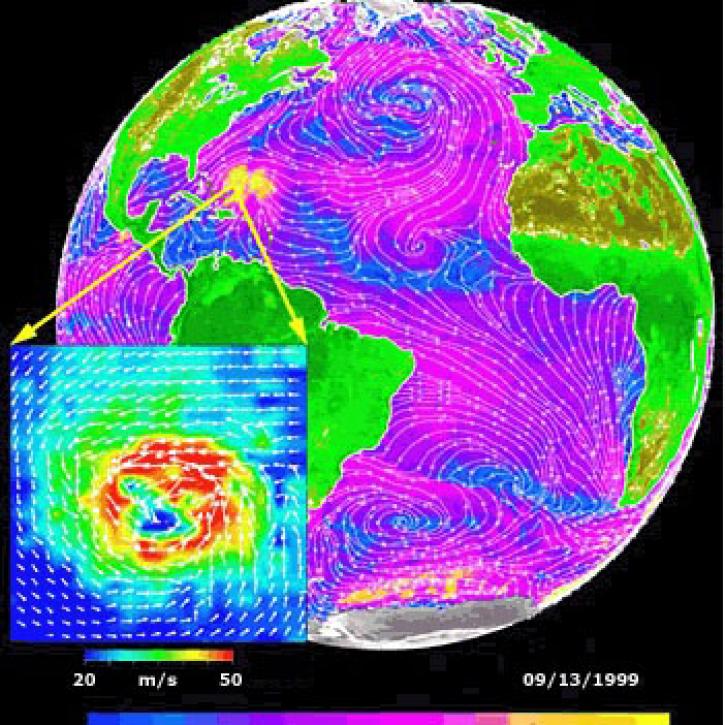
Data from NASA satellites allow researchers to detect potential hurricanes up to two days earlier than with traditional forecasting methods.
Feature Article
July 22, 2020

Remote sensing helps track the drift of harmful pollutants following the World Trade Center collapse.
Feature Article
July 22, 2020

ASTER data help evaluate fire scars by using VNIR to find differences in vegetation.
Feature Article
July 22, 2020
Synthetic Aperture Radar aboard the JERS-1 satellite collects data from the world's tropical forests.
Feature Article
July 22, 2020
SHOWING 8 OF 2379