We are in the process of migrating all NASA Earth science data sites into Earthdata from now until end of 2026. Not all NASA Earth science data and resources will appear here until then. Thank you for your patience as we make this transition.
Read about the Web Unification Project
Filters

Global data help experts rank the world's nations on environmental performance.
Feature Article
July 28, 2020

More than 1,750 children in the U.S. Upper Midwest had the chance to become scientists for a day thanks a program at the University of Toledo.
Feature Article
July 28, 2020
Amazon discharge is affected by periodic El Niño events.
Feature Article
July 28, 2020

TOPEX/Poseidon data help a scientist find a rise in global mean sea level.
Feature Article
July 28, 2020

Researchers use innovative techniques to protect the newly constructed Qinghai-Xizang railroad across the Tibetan Plateau from permafrost.
Feature Article
July 28, 2020

As wildlands shrink, scientists study the ecologies that people have tamed.
Feature Article
July 28, 2020

NSCAT wind vectors and SSM/I precipitable water color images reveal the physics in action for typhoons.
Feature Article
July 28, 2020
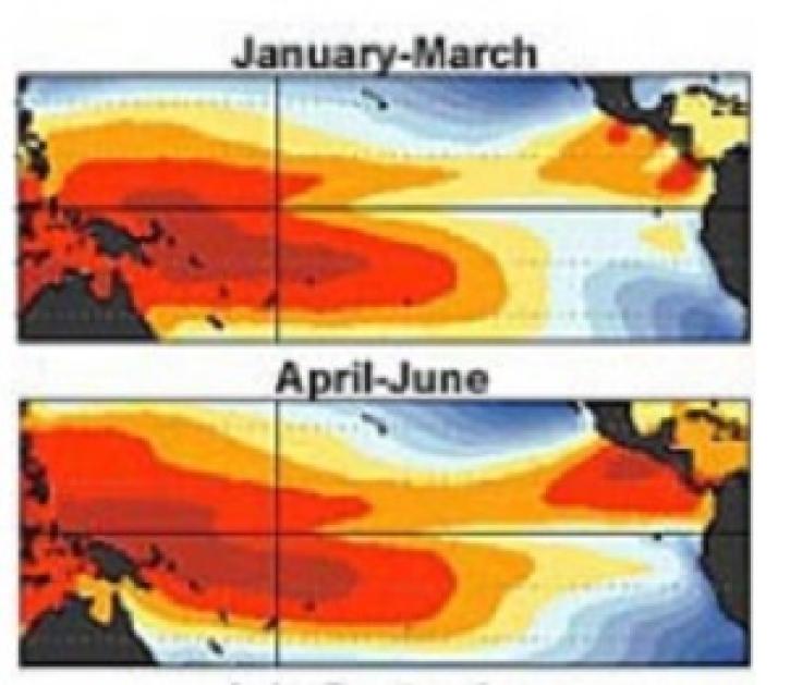
Scientists use ENSO as a test for a climate model examining the change in heat trapped by greenhouse gases.
Feature Article
July 28, 2020
SHOWING 8 OF 2379