Science Objectives
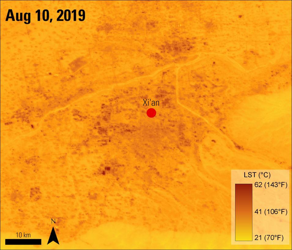
The authors chose to use ISS ECOSTRESS data due to its 70-meter resolution and repeat coverage throughout the day based on the orbit of the ISS. A local climate zone (LCZ) classification was used to categorize areas within the city into seven classes, including compact high-rise, compact midrise, compact low-rise, open high-rise, open midrise, open low-rise, and scattered trees. These classifications were used to examine how LST differed between the types of LCZs.
Instruments Used
First, the authors used the ISS ECOSTRESS cloud mask (ECO2CLD) data to identify cloud pixels. The mean LST was then calculated for each LCZ by averaging the LST of the cloudless pixels.
Major Findings
The authors found several patterns across the LCZs. The highest LST values were more associated with compact areas, with the highest mean LST value of 38.9°C (102.02°F). The authors also found that heat in compact LCZs increased faster than in areas with open, spread out buildings. During the day, the compact low-rise LCZ had the highest mean LST. Areas with low-rise buildings were found to have higher LSTs than areas with high-rise buildings in both compact and open areas. The authors state this could be due to high-rise buildings casting shadows, cooling parts of their area.
Vegetated areas experienced a lower LST, with a mean value of 23.5°C (74.3°F). At night, areas with compact buildings still had higher LST values but the difference was found to be insignificant. It was also found that compact low-rise and vegetated areas had the largest temperature contrasts of 5°C during the day and 2°C at night. The authors believe their findings will improve our understanding of the spatial heterogeneity of LST over complex urban landscapes. They believe this will help inform city planners who are creating heat mitigation strategies and shows that there is an exciting potential for using ISS ECOSTRESS LST data in future studies.
References
Publication Reference
Chang, Y., Xiao, J., Li, X., Middel, A., Zhang, Y., Gu, Z., Wu, Y., and He, S., 2021, Exploring diurnal thermal variations in urban local climate zones with ECOSTRESS land surface temperature data: Remote Sensing of Environment, v. 263, article 112544. doi:10.1016/j.rse.2021.112544
Image Reference
Granule ID:
ECOSTRESS_L2_LSTE_06206_007_20190810T040328_0601_02
AppEEARS Team. (2021). Application for Extracting and Exploring Analysis Ready Samples (AppEEARS). Ver. 2.66. NASA EOSDIS Land Processes Distributed Active Archive Center (LP DAAC), USGS/Earth Resources Observation and Science (EROS) Center, Sioux Falls, South Dakota, USA. Accessed October 22, 2021.
Hook, S., G. Hulley. ECOSTRESS Land Surface Temperature and Emissivity Daily L2 Global 70 m V001. 2019, distributed by NASA EOSDIS Land Processes DAAC. Accessed 2021-10-22.


