SeaWIFS global carbon data
SeaWIFS chlorophyll data in the Atlantic ocean
SeaWIFS chlorophyll data in Baja California

SeaWiFS

Sea-viewing Wide Field-of-view Sensor

The Sea-viewing Wide Field-of-view Sensor (SeaWiFS) project provided quantitative data on global ocean bio-optical properties. Subtle changes in ocean color signify various types and quantities of marine phytoplankton (microscopic marine plants), which are key indicators of ocean diversity and health. The SeaWiFS Project developed and operated a research data system that processed, calibrated, validated, archived, and distributed data received from an Earth-orbiting ocean color sensor.

Data Centers

OB.DAAC

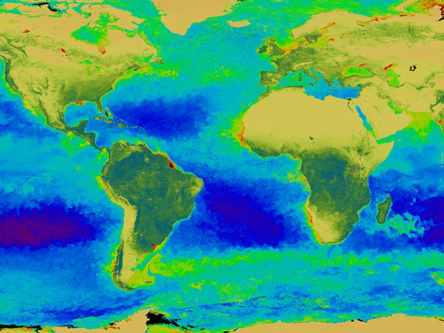
The SeaWiFS project is a part of NASA's Earth Science Enterprise, which is designed to look at our planet from space to better understand it as a system in both behavior and evolution. The concentration of phytoplankton can be derived from satellite observation and quantification of ocean color. This is due to the fact that the color in most of the world's oceans in the visible light region (wavelengths of 400-700 nm) varies with the concentration of chlorophyll and other plant pigments present in the water. This means that the more phytoplankton is present, the greater the concentration of plant pigments and the greener the water.

Ocean color data have been deemed critical by the oceanographic community for the study of ocean primary production and global biogeochemistry. "Primary production" refers to the organic material in the sea that is produced by "primary producers." These "primary producers," i.e. algae and some bacteria, exist at the lowest levels of the food chain and use sunlight or chemical energy, rather than other organic material, as sources of energy. It is thought that marine plants remove carbon from the atmosphere at a rate equivalent to terrestrial plants, but knowledge of interannual variability is very poor.

Since an orbiting instrument can view every square kilometer of cloud-free ocean every 48 hours, satellite-acquired ocean color data constitute a valuable tool for determining the abundance of ocean biota on a global scale and can be used to assess the ocean's role in the global carbon cycle and the exchange of other critical elements and gases between the atmosphere and the ocean. SeaWiFS operated as a follow-on sensor to the Coastal Zone Color Scanner (CZCS), which ceased operations in 1986. In the first arrangement of its kind, the U.S. government procured space-based environmental remote sensing data for research purposes from a commercial operator. Orbital Sciences Corporation (OSC) integrated SeaWiFS into its SeaStar spacecraft and marketed the data for commercial and operational use.

Animation showing a massive sandstorm captured by SeaWiFS.
Caption

A massive sandstorm blowing off the northwest African desert blanketed hundreds of thousands of square miles of the eastern Atlantic Ocean with a dense cloud of Saharan sand. The massive nature of this particular storm was first seen in a SeaWiFS image on Saturday, Feb. 26, 2000, when it reached over 1,000 miles into the Atlantic. These storms and the rising warm air can lift dust 15,000 feet or so above the African deserts and then out across the Atlantic, many times reaching as far as the Caribbean where they often require the local weather services to issue air pollution alerts as was recently the case in San Juan, Puerto Rico. Recent studies by the U.S. Geological Survey (USGS) have linked the decline of the coral reefs in the Caribbean to the increasing frequency and intensity of Saharan Dust events. By March 4, the cloud of dust had reached the northeast coast of South America. Credit: NASA's Ocean Biology Distributed Active Archive Center (OB.DAAC)

Program Objectives

The purpose of SeaWiFS data is to examine oceanic factors that affect global change and to assess the oceans' role in the global carbon cycle, as well as other biogeochemical cycles, through a comprehensive research program.

SeaWiFS data are being used to help clarify the magnitude and variability of chlorophyll and primary production by marine phytoplankton, and to determine the distribution and timing of spring blooms, i.e., the time of highly abundant growth. The scientific and technical experience gained in the SeaWiFS mission have been valuable preparation for the design and application of the Earth Observing System's Moderate resolution Imaging Spectroradiometer (MODIS) as well as future sensors such as the National Polar-orbiting Operational Environmental Satellite System (NPOESS) Visible Infrared Imaging Radiometer Suite (VIIRS).

Project Objectives

The purpose of the SeaWiFS Project has been to obtain accurate ocean color data from the world's oceans for a 5-year (minimum) period; to process these data in conjunction with ancillary data into meaningful biological parameters, such as photosynthesis rates; and to make these data readily available to researchers. NASA's Goddard Space Flight Center developed the data processing and archiving system and oversaw the effort to ensure the integrity of the final products.

Project Overview

The success of the SeaWiFS mission is determined by the quality of the ocean color data and their availability. Inherent in any space flight mission for scientific applications are Project elements that assure this success. The OV-2 satellite broadcasted SeaWiFS data in real time to the GSFC High-Resolution Picture Transmission (HRPT) station, as well as to other stations, and recorded data — Global Area Coverage (GAC) and Local Area Coverage (LAC) — to NASA Goddard, NASA's Wallops Flight Facility, and ORBIMAGE. These HRPT, GAC, and LAC data were then transferred to the SeaWiFS Data Processing System (SDPS). The SDPS was comprised of a number of elements: namely, SeaWiFS data processing; calibration, validation, and data quality; data capture; and mission operations.

The data processing element receives raw spacecraft data and generates standard global ocean color data products. The standard products go to tNASA's Ocean Biology Distributed Active Archive Center (OB.DAAC), which is responsible for archiving and distributing SeaWiFS data to the scientific community.

The calibration and validation element is responsible for establishing and updating calibration procedures for SeaWiFS data, using correlative data for validating higher-level products; analyzing trends and deviations; and collecting ancillary data sets such as winds, ozone, and atmospheric pressure that are used in data processing.

The mission planning element serves as the link between ORBIMAGE and the SeaWiFSProject Office (SPO) for the purposes of reporting problems, monitoring the automatic data measurements and transmission (telemetry), and scheduling the scientific aspects of mission operations. It also provides navigation information and the orbital elements required for data processing and data collection. ORBIMAGE is responsible for the space segment, mission management, and the command and data acquisition station.

The data calibration, processing, and validation program calibrated the SeaWiFS data; developed the mathematical procedures (algorithms) for operational atmospheric correction and for derived data; and validated the accuracy of the derived products, such as the concentration of chlorophyll a. The atmospheric correction is critical because only about 5% of the light seen at the satellite is reflected from within the ocean (water-leaving radiances). NASA and the SPO have placed the highest priority on assuring the accuracy of calculated water-leaving radiances, globally, over the life of the mission. Although meeting these requirements was an ongoing process, the accuracy and stability of the radiances was well established, and development of global and regional biogeochemical algorithms proceeded on many fronts. Some of this work was done at GSFC, while the remainder has been done externally, by members of the ocean science community.

Included in the processing program was the development of atmospheric correction and bio-optical algorithms required to produce the derived products. The atmospheric correction algorithms for processing SeaWiFS data included a number of improvements over the Coastal Zone Color Scanner Experiment (CZCS) algorithms. Datasets from field studies were collected to validate these improvements.

The field studies mentioned above were external activities. Internal activities included the development of bio-optical databases and the comparison of atmospheric correction and bio-optical algorithms. Investigators funded by NASA to assist with algorithm development had access to these databases.

Atmospheric correction algorithms used external data such as ozone concentrations and surface pressure fields. The quality of these fields was assessed before the data were incorporated into the processing. Finally, prior to the release of the derived products, quality assessment and control functions were performed by comparison of historical and simultaneous field observations submitted to the SPO by field programs and individual investigators.

SeaWiFS produced scientific data of two spatial resolutions: LAC have been broadcast continuously and recorded selectively, while GAC have been recorded continuously onboard the spacecraft. NASA's Goddard Space Flight Center received LAC direct broadcasts routinely for the east coast of the U.S., and various HRPT stations around the world received other real-time LAC broadcasts. NASA's Wallops Flight Facility received recorded GAC and LAC data, which it forwarded to the SDPS at NASA Goddard.

In order to meet the science goals, the SPO objectives were to obtain full GAC data every two days, which required nearly complete use of onboard recording capability and transmission time to NASA Goddard. The limited space for LAC recording was allocated, in priority order, to 1) monitoring essential sensor functions; 2) covering key optical calibration and validation activities; and 3) science studies which require full-resolution data.