We are in the process of migrating all NASA Earth science data sites into Earthdata from now until end of 2026. Not all NASA Earth science data and resources will appear here until then. Thank you for your patience as we make this transition.
Read about the Web Unification Project
Sentinel-2 MSI Resources
Earthdata resources for users working with NASA’s Multispectral Instrument include tutorials and other learning resources, news announcements such as instrument updates and data releases, user guides and related documents, and frequently asked questions.
Sentinel-2 MSI Learning Resources

Esta capacitación de ARSET cubre cómo usar datos del UN Biodiversity Lab para conservación y desarrollo sostenible.
Training
April 14 - May 4, 2022
This ARSET training shares how to apply UN Biodiversity Lab remote sensing/geospatial data for conservation and sustainable development priorities.
Training
April 14 - May 4, 2022

Esta capacitación de ARSET cubre técnicas avanzadas de radar usando polarimetría para extraer información de cultivos.
Training
April 12 - May 3, 2022
This ARSET training presents more advanced radar remote sensing techniques using polarimetry to extract crop structural information.
Training
April 12 - May 3, 2022

Esta capacitación de ARSET cubre el Kit de herramientas de observación de la Tierra para ciudades y asentamientos humanos sostenibles.
Training
Jan. 27 - Feb. 10, 2022
This ARSET training provides an overview of the Earth Observations Toolkit for Sustainable Cities and Human Settlements.
Training
Jan. 27 - Feb. 10, 2022

This ARSET training reviews pre-fire risk assessment and post-fire mapping using open-source tools like Google Earth Engine.
Training
Jan. 18-20, 2022

This ARSET training provides participants with the skills to combine in situ measurements and optical remote sensing data to assess water quality.
Training
Nov. 30 - Dec. 7, 2021
SHOWING 8 OF 63
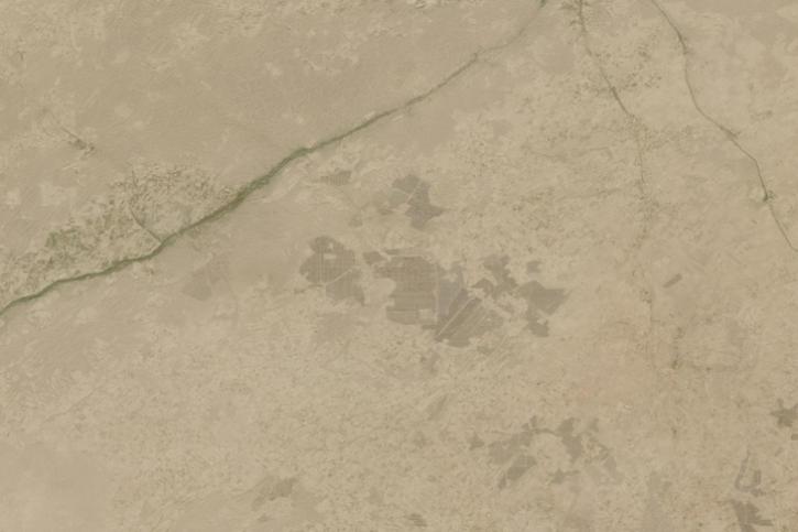
Image captured on March 25, 2024, by the MultiSpectral Instrument (MSI) aboard the ESA (European Space Agency) Sentinel-2B satellite.
Worldview Image of the Week
March 28, 2024
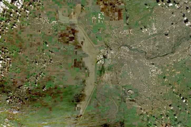
Image captured on Feb 18, 2024, by the MSI instrument aboard ESA's Sentinel 2B satellite.
Worldview Image of the Week
Feb. 22, 2024
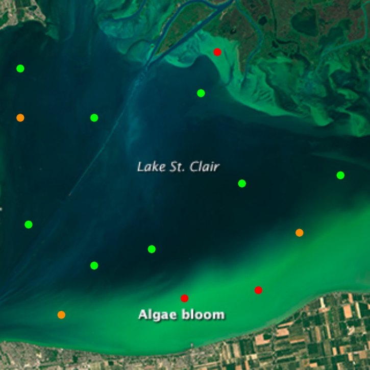
The open-source Cyanobacteria Finder (CyFi) uses machine learning to pinpoint areas that may contain harmful algal blooms in lakes, reservoirs, rivers, and other small water bodies.
Blog
Feb. 13, 2024

NASA researchers are tweaking algorithms and combining data from multiple satellites to track tropical forest fires in Brazil.
Feature Article
Feb. 1, 2024
SHOWING 4 OF 66
Frequently Asked Questions
Earthdata Forum
Our online forum provides a space for users to browse thousands of FAQs about research needs, data, and data applications. You can also submit new questions for our experts to answer.
Submit Questions to Earthdata Forumand View Expert Responses