We are in the process of migrating all NASA Earth science data sites into Earthdata from now until end of 2026. Not all NASA Earth science data and resources will appear here until then. Thank you for your patience as we make this transition.
Read about the Web Unification Project
MODIS Resources
Earthdata resources for users working with NASA’s Moderate Resolution Imaging Spectroradiometer (MODIS) data include tutorials and other learning resources, news announcements such as instrument updates and data releases, user guides and related documents, and frequently asked questions.
MODIS Learning Resources

This ARSET training introduces remote sensing observations for monitoring the water level of lakes.
Training
Feb. 9-23, 2021

The webinar introduces satellite remote sensing, radiance conversion, image classification, and geophysical product creation, and more.
Webinar
Jan. 29, 2021

Learn how MODIS data helped researchers assess the impact of pandemic-triggered lockdowns on air pollution in India.
Data in Action
Jan. 4, 2021

Discover how LP DAAC data supports long-term vegetation trend analysis in East Africa and live fuel moisture estimation in fire-prone shrublands of Spain.
Data in Action
Nov. 30, 2020

Discover how a NASA DEVELOP team used NASA Earth science remote sensing data to observe the impacts urban growth has had on the city of Huntsville, Alabama.
Data in Action
Nov. 17, 2020

This ARSET training covers the use of remote sensing in determining and explaining urban heat islands, and ways to mitigate the effects.
Training
Nov. 10-24, 2020

This ARSET training focuses on mapping and monitoring mangroves and how it aligns with UN Sustainable Development Goals (SDGs).
Training
Nov. 5-19, 2020

During this webinar we will introduce several of the NSIDC DAAC snow-focused NASA missions and data products, followed by a live demonstration teaching participants how to discover, access, and couple snow data across varying geospatial scales using Python.
Webinar
Nov. 4, 2020
SHOWING 8 OF 222
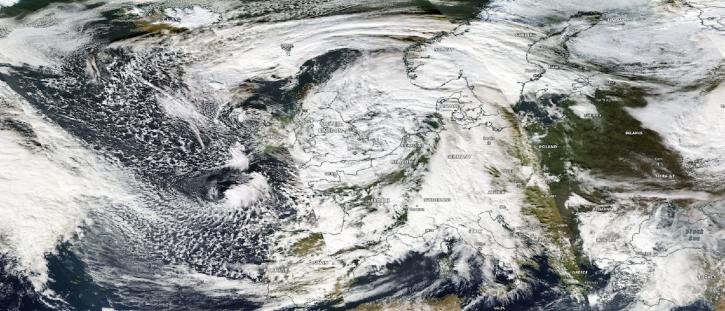
Image captured on Nov 2, 2023, by the MODIS instrument aboard NASA's Aqua satellite.
Worldview Image of the Week
Nov. 2, 2023

NASA Earth science data help Dr. Gonzalo González Abad produce retrievals of formaldehyde and other atmospheric trace gases.
Data User Story
Oct. 26, 2023

The migration of historical satellite data from NASA's Level-1 and Atmosphere Archive and Distribution System Distributed Active Archive Center (LAADS DAAC) to the Earthdata Cloud brings new efficiencies to using these data.
News
Oct. 18, 2023
A summary of datasets, products, and resources released by NASA’s Distributed Active Archive Centers (DAACs) in September 2023.
News
Sept. 29, 2023
SHOWING 4 OF 527
Frequently Asked Questions
Earthdata Forum
Our online forum provides a space for users to browse thousands of FAQs about research needs, data, and data applications. You can also submit new questions for our experts to answer.
Submit Questions to Earthdata Forumand View Expert Responses