We are in the process of migrating all NASA Earth science data sites into Earthdata from now until end of 2026. Not all NASA Earth science data and resources will appear here until then. Thank you for your patience as we make this transition.
Read about the Web Unification Project
AVHRR Resources
Earthdata resources for users working with NASA’s Advanced Very High Resolution Radiometer (AVHRR) instrument include tutorials and other learning resources, news announcements such as instrument updates and data releases, user guides and related documents, and frequently asked questions.
AVHRR Learning Resources

Use a Python script to convert Infrared Global Geostationary Composite McIDAS data into PNG format and display the infrared composite as an image outside of McIDAS software.
Data Recipe
Dec. 1, 2022

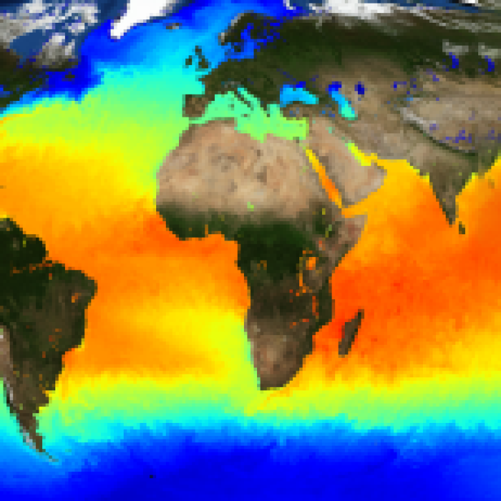
Datasets from the Estimating the Circulation of the Ocean (ECCO) project can transform ocean temperature monitoring.
Data in Action
May 26, 2021

The webinar introduces satellite remote sensing, radiance conversion, image classification, and geophysical product creation, and more.
Webinar
Jan. 29, 2021

This visualization shows 34 years of Earth's seasonal vegetation changes, driven by its orbit and tilt, using NASA's MEaSUREs Vegetation Index and Phenology (VIP) Version 4 collection.
Tutorial
Nov. 22, 2016

Read stories from the 2015 issue of Sensing our Planet to learn about the many uses of MODIS data distributed by LP DAAC.
Data in Action
June 1, 2016

NASA's OSCAR data were used to analyze ocean currents to track debris fields for Malaysian Airlines flight 370.
Data in Action
April 4, 2014
SHOWING 6 OF 6
The public release of the NAVO GHRSST Level 4 K10-SST GDS2.0 product provides global daily analyzed SST at a 1-meter reference depth.
News
Nov. 4, 2020

High-resolution sea surface temperature data can be used to study marine heat waves and the health of marine ecosystems.
Feature Article
Nov. 4, 2020

The range of data available for modeling also underscores the importance of communication among those working at the interface.
Feature Article
July 28, 2020

Characterizing MODIS performance involves an innovative and international collaboration of scientists.
Feature Article
July 28, 2020
SHOWING 4 OF 38
Frequently Asked Questions
Earthdata Forum
Our online forum provides a space for users to browse thousands of FAQs about research needs, data, and data applications. You can also submit new questions for our experts to answer.
Submit Questions to Earthdata Forumand View Expert Responses