We are in the process of migrating all NASA Earth science data sites into Earthdata from now until end of 2026. Not all NASA Earth science data and resources will appear here until then. Thank you for your patience as we make this transition.
Read about the Web Unification Project
AMSR SIPS Learning Resources
Webinars, tutorials, data recipes and more to help you work with AMSR SIPS.
Filters

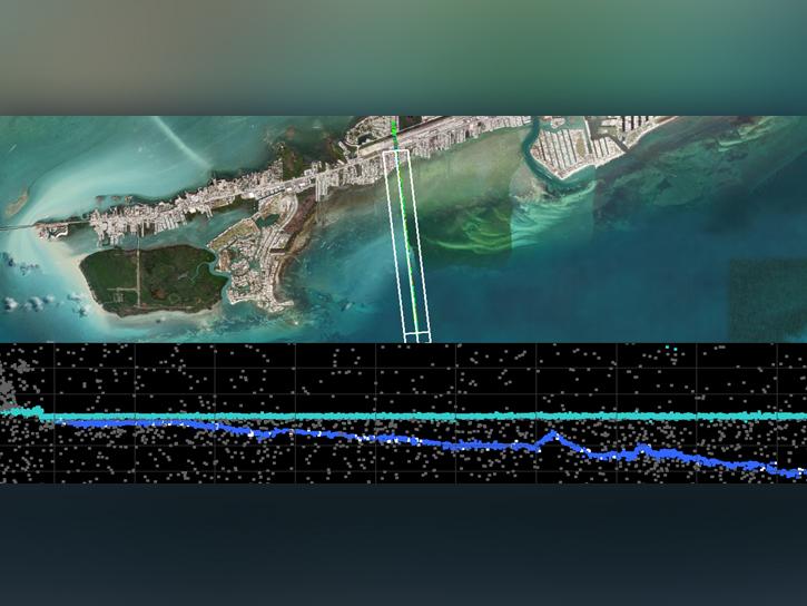
This ARSET training covers NASA data providing near global coverage of coastal and near-shore satellite-derived bathymetry (SDB) measurements.
Training
Dec. 2-4, 2025

Join us on Wed., Nov. 19, 2025, at 2 p.m. EST for the fifth NASA ICESat-2 data training webinar. Participants will learn about ICESat-2 inland surface water data, services, and tools.
Webinar
Nov. 13, 2025

The fourth NASA ICESat-2 data training webinar features ICESat-2 sea ice datasets, services, and tools.
Webinar
July 25, 2025
In the third webinar of the ICESat-2 series, learn how to discover, access, and work with a new bathymetric data product, ATL24.
Webinar
March 24, 2025
In the second ICESat-2 webinar, learn how to work with land and vegetation height data. A live demonstration will showcase the SlideRule Earth web service which provides on-demand science data processing.
Webinar
Jan. 31, 2025

This is the first in a five-part webinar series to introduce NASA's Ice, Cloud, and land Elevation-2 (ICESat-2) platform and the platform's data, tools, and applications.
Webinar
Oct. 28, 2024
This data recipe provides instructions on how to use a Python script to convert Infrared Global Geostationary Composite McIDAS data into PNG format and display the infrared composite as an image outside of McIDAS software.
Data Recipe
Oct. 2, 2024
The Field Campaign Explorer (FCX) enables 3D analysis of Earth science datasets. This Earthdata webinar features use cases and information about this system.
Webinar
Sept. 26, 2024
SHOWING 8 OF 67