We are in the process of migrating all NASA Earth science data sites into Earthdata from now until end of 2026. Not all NASA Earth science data and resources will appear here until then. Thank you for your patience as we make this transition.
Read about the Web Unification Project
Terrestrial Hydrosphere Learning Resources
Webinars, tutorials, data recipes and more to help you work with Terrestrial Hydrosphere.
Filters
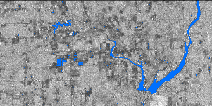
In this webinar, we will demonstrate approaches for using SAR datasets in GIS environments to detect landscape change and map flooding events with a focus on Sentinel-1 datasets.
Webinar
July 10, 2020

Esta capacitación de ARSET presenta una visión general de cómo utilizar observaciones de GRACE para apoyar la gestión de recursos hídricos.
Training
June 25, 2020
This ARSET training provides an overview of how GRACE observations can be used to support water resources management.
Training
June 25, 2020

Researchers used NASA satellite data to improve water resource management in South and Southeast Asia.
Data in Action
May 13, 2020

This ARSET training focuses on using interferometric synthetic aperture radar for characterizing landslides and generating a digital elevation model.
Training
Dec. 3-5, 2019
Esta capacitación de ARSET cubre el uso de SAR interferométrico para caracterizar deslizamientos y generar modelos de elevación digitales.
Training
Dec. 3-5, 2019

This ARSET training focuses on describing NASA digital elevation data and its application in deriving river basin information using HydroSHEDS.
Training
Nov. 26, 2019

This ARSET training introduces the applications of ECOSTRESS for crop health, volcanoes, urban heat, wildland fires, coastal systems, and much more.
Training
Nov. 20, 2019
SHOWING 8 OF 82
Frequently Asked Questions
Earthdata Forum
Our online forum provides a space for users to browse thousands of FAQs about research needs, data, and data applications. You can also submit new questions for our experts to answer.
Submit Questions to Earthdata Forumand View Expert Responses