NASA has geodetics datasets that help researchers characterize the shape of Earth and the motion of its components. Access a range of data and data tools such as AppEEARS, Worldview, and Giovanni to make the most of geodetics data.
Geodetics Data Access and Tools
Geodetics Datasets
| Dataset Sort descending | Version | Platform | Instrument | Temporal Extent | Spatial Extent | Spatial Resolution | Data Format |
|---|---|---|---|---|---|---|---|
| Satellite Laser Ranging (SLR) Satellite Orbit Products from NASA CDDIS | 1 | GROUND STATIONS | SLR | 1992-01-01 to Present |
N: 90 S: -90 E: 180 W: -180 |
Standard Product 3 (SP3) | |
| Suomi-NPP VIIRS Level-1A Geolocation Data, version 2 | 2 | Suomi-NPP | VIIRS | 2012-01-02 to Present |
N: 90 S: -90 E: 180 W: -180 |
netCDF-4 | |
| Terra MODIS Level-1A Geolocation Data, version 1 | 1 | Terra | MODIS | 2000-02-24 to Present |
N: 90 S: -90 E: 180 W: -180 |
netCDF-4 | |
| Very Long Baseline Interferometry (VLBI) Auxiliary Files from NASA CDDIS | 1 | GROUND-BASED OBSERVATIONS | VLBI Station | 2005-01-01 |
N: 90 S: -90 E: 180 W: -180 |
ASCII | |
| Very Long Baseline Interferometry (VLBI) Celestial Reference Frame (CRF) solution products from NASA CDDIS | 1 | GROUND-BASED OBSERVATIONS | VLBI Station | 2002-01-01 to Present |
N: 90 S: -90 E: 180 W: -180 |
IERS CRF | |
| Very Long Baseline Interferometry (VLBI) Daily Intensive Solution Product (DSNI) | 1 | GROUND STATIONS | VLBI Station | 2007-08-28 to Present |
N: 90 S: -90 E: 180 W: -180 |
SINEX | |
| Very Long Baseline Interferometry (VLBI) Daily SINEX Independent Solution product (DSNX) from NASA CDDIS | 1 | GROUND STATIONS | VLBI Station | 1984-02-03 to Present |
N: 90 S: -90 E: 180 W: -180 |
SINEX | |
| Very Long Baseline Interferometry (VLBI) Data and Products Supporting Information from NASA CDDIS | 1 | GROUND STATIONS | RF ANTENNA | 1979-01-01 to Present |
N: 90 S: -90 E: 180 W: -180 |
ASCII | |
| Very Long Baseline Interferometry (VLBI) data from NASA CDDIS | 1 | GROUND STATIONS | VLBI Station | 1979-08-03 to Present |
N: 90 S: -90 E: 180 W: -180 |
||
| Very Long Baseline Interferometry (VLBI) Earth Orientation Parameters (EOP) Products from NASA CDDIS | 1 | GROUND-BASED OBSERVATIONS | VLBI Station | 1979-01-01 to Present |
N: 90 S: -90 E: 180 W: -180 |
Text | |
| Very Long Baseline Interferometry (VLBI) Intensive Earth Orientation Parameter (EOP-I) Series products from NASA CDDIS | 1 | GROUND-BASED OBSERVATIONS | VLBI Station | 1979-01-01 to Present |
N: 90 S: -90 E: 180 W: -180 |
ASCII | |
| Very Long Baseline Interferometry (VLBI) Positions Products from NASA CDDIS | 1 | GROUND STATIONS | VLBI Station | 1980-01-01 to Present |
N: 90 S: -90 E: 180 W: -180 |
Software INdependent EXchange (SINEX) | |
| Very Long Baseline Interferometry (VLBI) Session Earth Orientation Parameter Series (EOP-S) Product from NASA CDDIS | 1 | GROUND STATIONS | VLBI Station | 2002-02-13 to 2023-12-11 |
N: 90 S: -90 E: 180 W: -180 |
EOP Transfer Format | |
| Very Long Baseline Interferometry (VLBI) Tropospheric Parameters (TROP) products from NASA CDDIS | 1 | GROUND STATIONS | VLBI Station | 2001-12-30 to Present |
N: 90 S: -90 E: 180 W: -180 |
EOP Transfer Format | |
| VIIRS/JPSS1 Day/Night Band Resolution Terrain Corrected Geolocation 6 Min L1 Swath 750m NRT | 2.1 | NOAA-20 | VIIRS | 2022-01-01 |
N: 90 S: -90 E: 180 W: -180 |
750 Meters x 750 Meters | netCDF-4 |
| VIIRS/JPSS1 Imagery Resolution Terrain Corrected Geolocation 6 Min L1 Swath 375m NRT | 2.1 | NOAA-20 | VIIRS | 2022-01-01 |
N: 90 S: -90 E: 180 W: -180 |
375 Meters x 375 Meters | netCDF-4 |
| VIIRS/JPSS1 Moderate Resolution Terrain Corrected Geolocation 6 Min L1 Swath 750m NRT | 2.1 | NOAA-20 | VIIRS | 2022-01-01 |
N: 90 S: -90 E: 180 W: -180 |
750 Meters x 750 Meters | NetCDF |
| VIIRS/NPP Day/Night Band Terrain Corrected Geolocation L1 6-Min Swath 750 m | 2 | Suomi-NPP | VIIRS | 2012-01-19 to Present |
N: 90 S: -90 E: 180 W: -180 |
750 Meters x 750 Meters | NetCDF-4 |
| VIIRS/NPP Imagery Resolution Terrain Corrected Geolocation 6-Min L1 Swath 375 m | 2 | Suomi-NPP | VIIRS | 2012-01-19 to Present |
N: 90 S: -90 E: 180 W: -180 |
netCDF-4 | |
| VIIRS/NPP Moderate Resolution Terrain-Corrected Geolocation L1 6-Min Swath 750 m | 2 | Suomi-NPP | VIIRS | 2012-01-19 to Present |
N: 90 S: -90 E: 180 W: -180 |
750 Meters x 750 Meters | netCDF-4 |
Featured Geodetics Observation Method: GNSS
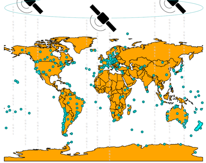
A Global Navigation Satellite System (GNSS) is a space geodesy technology that provides autonomous geospatial positioning around the world. One such system is the U.S. Global Positioning System (GPS), which is made up of 24 satellites, each traveling in a 12-hour orbit. A similar system is the GLObal NAvigation Satellite System (GLONASS) constellation consisting of 24 satellites. Each system is designed so that multiple satellites are within range of any point on Earth in order to precisely determine its location. GNSS data can used to determine location and positioning around Earth as well as to study geophysics, the motions of tectonic plates and their displacements due to earthquakes, Earth orientation, and atmospheric properties among many other things.
Frequently Asked Questions
Earthdata Forum
Our online forum provides a space for users to browse thousands of FAQs about research needs, data, and data applications. You can also submit new questions for our experts to answer.
Submit Questions to Earthdata Forumand View Expert Responses