We are in the process of migrating all NASA Earth science data sites into Earthdata from now until end of 2026. Not all NASA Earth science data and resources will appear here until then. Thank you for your patience as we make this transition.
Read about the Web Unification Project
Sea Surface Topography News
Articles, resources, and announcements from Sea Surface Topography.
Geodesists seek crazy precision in measuring sea level.
Feature Article
Dec. 28, 2020


Satellites and ocean bottom instruments tell similar stories.
Feature Article
Dec. 28, 2020

The global average sea level is rising. Dr. Philip Thompson uses NASA Earth science data to explore how—and when—this will affect vulnerable communities.
Data User Story
Dec. 22, 2020

Who uses NASA Earth science data? Cara Wilson, to better understand the possible connection between harmful algal blooms and southern right whale mortality.
Data User Story
Dec. 22, 2020

Data from NASA’s ICESat-2 mission provide incredibly accurate measurements of Earth elevation change—and much more.
Feature Article
Nov. 4, 2020
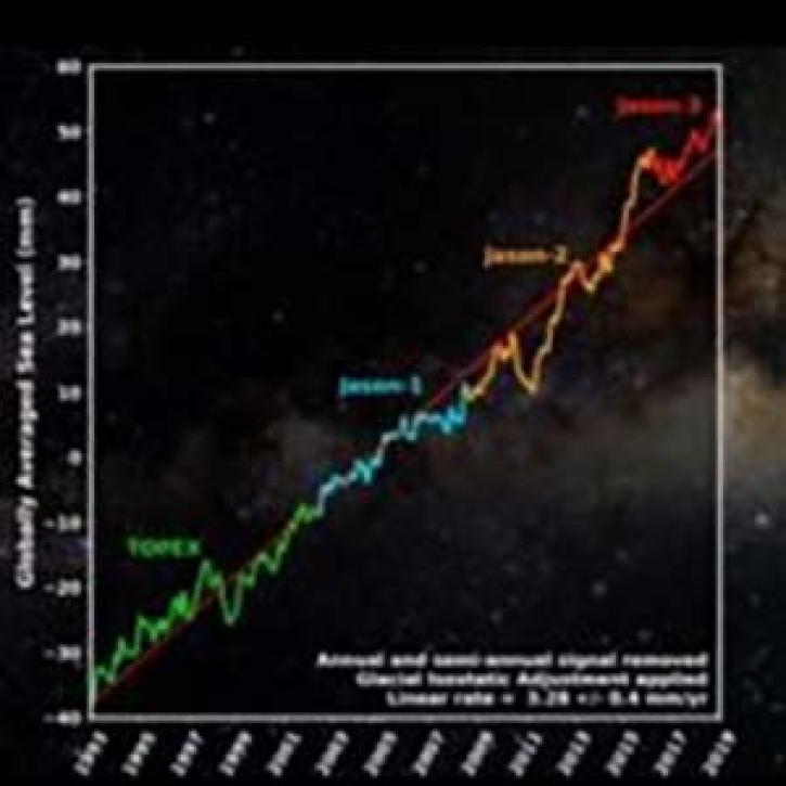
Using data from four ocean altimetry missions, a new PO.DAAC animation shows more than a quarter-century of global average sea level change.
News
Nov. 4, 2020
SHOWING 8 OF 43