We are in the process of migrating all NASA Earth science data sites into Earthdata from now until end of 2026. Not all NASA Earth science data and resources will appear here until then. Thank you for your patience as we make this transition.
Read about the Web Unification Project
Topography Data Access and Tools
NASA data detail topography across the land surface, ocean, cryosphere, terrestrial hydrosphere and within the context of climate change. Our datasets and tools help researchers translate these interconnected data points into actionable knowledge.
Table of contents
Topography Datasets
| Dataset | Platforms | Instruments | Temporal Extent | Location Keywords | Spatial Extent | Data Format |
|---|---|---|---|---|---|---|
| ALOS PALSAR Level 1.1 Product | ALOS | PALSAR | 2006-01-23 to 2011-05-23 | N: 90 S: -90 E: 180 W: -180 | ||
| ALOS PALSAR Level 1.5 Product | ALOS | PALSAR | 2006-03-23 to 2011-04-22 | N: 90 S: -90 E: 180 W: -180 | ||
| ALOS PALSAR Low Resolution Radiometric Terrain Corrected Product | ALOS | PALSAR | 2006-03-23 to 2011-04-22 | N: 90 S: -90 E: 180 W: -180 | ||
| ALOS_AVNIR_OBS_ORI | ALOS | AVNIR-2 | 2006-01-23 to 2011-05-23 | N: 90 S: -90 E: 180 W: -180 | ||
| ALOS_PALSAR_KMZ | ALOS | PALSAR | 2006-03-23 to 2011-04-22 | N: 90 S: -90 E: 180 W: -180 | ||
| ALOS_PALSAR_LEVEL2.2 | ALOS | PALSAR | 2006-01-23 to 2011-05-23 | N: 90 S: -90 E: 180 W: -180 | ||
| Altimeter Corrected Elevations, Version 2 (ACE2) | STS-99 | SRTM | 1994-01-01 to 2005-12-31 | GLOBAL | N: 90 S: -90 E: 180 W: -180 | GeoTIFF, PDF, PNG |
| Arctic Alaska Vegetation, Geobotanical, Physiographic Maps, 1993-2005 | FIELD SURVEYS, LANDSAT-5 | VISUAL OBSERVATIONS, AVHRR | 1993-06-01 to 2005-03-30 | N: 71.3703 S: 57.0847 E: -138.542 W: -173.052 | multiple | |
| Arctic Circumpolar Distribution and Soil Carbon of Thermokarst Landscapes, 2015 | MODELS | Computer | 2015-01-01 to 2015-12-31 | N: 83.6162 S: 45.5364 E: 180 W: -180 | Shapefile | |
| Arctic Vegetation Plots at Umiat, North Slope, Alaska, 1951 | FIELD SURVEYS | SOIL MOISTURE PROBE | 1951-07-01 to 1951-08-31 | N: 69.37 S: 69.37 E: -152.13 W: -152.13 | CSV |
Topography Featured Observation Method: ICESat-2
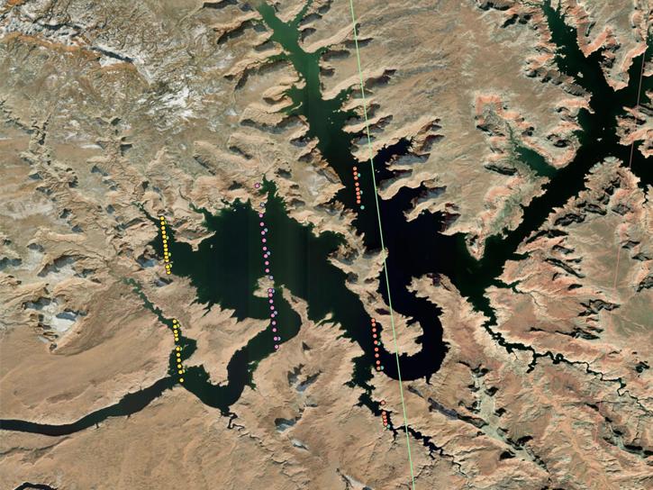
NASA's Ice, Cloud, and Land Elevation Satellite-2 (ICESat-2) allows scientists to measure the elevation of ice sheets, glaciers, sea ice, and land across Earth's temperate and tropical regions, as well as take stock of the vegetation in forests worldwide. ICESat-2 carries the Advanced Topographic Laser Altimeter System (ATLAS), which sends 10,000 pulses of laser light to the ground per second and then measures how long it takes them be reflected back by the surface to determine the area's elevation.
Learn more about ICESat-2/ATLAS near real-time data provided by NASA's Land, Atmosphere Near real-time Capability for Earth observation (LANCE).
ICESat-2 carries the Advanced Topographic Laser Altimeter System (ATLAS), which sends pulses of laser light to the ground, collects the returning photons in a telescope, and records the photon travel time.
Data from NASA’s ICESat-2 mission provide incredibly accurate measurements of Earth elevation change—and much more.
8 MIN READ
The five new datasets are the result of a joint effort by NASA’s Satellite Needs Working Group Management Office (SNWG MO), ICESat-2 team, and Land, Atmosphere Near real-time Capability for EOS (LANCE).
3 MIN READ
This is the first in a five-part webinar series to introduce NASA's Ice, Cloud, and land Elevation-2 (ICESat-2) platform and the platform's data, tools, and applications.
This ACCESS 2015 project focused on OpenAltimetry, a cloud-ready web-based application for discovery, access, and visualization of ICESat and ICESat-2 data.
Frequently Asked Questions
Earthdata Forum
Our online forum provides a space for users to browse thousands of FAQs about research needs, data, and data applications. You can also submit new questions for our experts to answer.
Submit Questions to Earthdata Forumand View Expert Responses


