We are in the process of migrating all NASA Earth science data sites into Earthdata from now until end of 2026. Not all NASA Earth science data and resources will appear here until then. Thank you for your patience as we make this transition.
Read about the Web Unification Project
Filters

As International Women’s Day occurs in March we decided to look more closely at the experience of women in the sciences.
Blog
Dec. 7, 2023
Dr. Emily Foshee advances our ability to understand and predict mountain gap winds that result from the interaction between the larger scale atmospheric flow and terrain.
Blog
Dec. 7, 2023
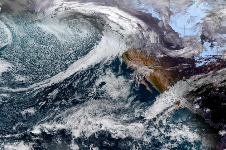
Image captured on Dec 4, 2023, by the ABI instrument aboard the GOES-West satellite.
Worldview Image of the Week
Dec. 7, 2023

SWOT data reveals the topography of the ocean surface at finer scales than ever before.
Data in Action
Dec. 7, 2023

Activities will highlight the use of advanced concepts to prototype, develop, and test data and information systems for Earth observations.
Blog
Dec. 6, 2023
View a schedule of events led by members of NASA's Global Hydrometeorology Resource Center DAAC (GHRC DAAC) at the AGU Fall Meeting.
Blog
Dec. 5, 2023

A summary of datasets, products, and resources released by NASA’s Distributed Active Archive Centers (DAACs) in November 2023.
News
Dec. 5, 2023

CASEI is a centralized web interface for users to rapidly access information and data products acquired by NASA’s airborne or field investigations.
Blog
Dec. 5, 2023
SHOWING 8 OF 2379