Now That NISAR Launched, Here's What You Can Expect From the Data

The NISAR mission kicks off a new era in Earth observation, with two powerful radars tracking planetary change in unprecedented detail.

The world around us is in a perpetual state of motion: from forest growth to sea level rise to tectonic movement, almost nothing stays the same from one moment to the next. Understanding—and ultimately, predicting—how Earth’s surface evolves over time is an enduring challenge, and one that is crucial to helping communities make informed choices in industries such as agriculture production, disaster management, infrastructure maintenance, and climate response.

The July 30 launch of the NASA-ISRO Synthetic Aperture Radar (NISAR) satellite, a collaboration between NASA and the Indian Space Research Organization (ISRO), is on its way to revolutionize the study of change on Earth. Equipped with two synthetic aperture radars (SAR), an L-Band SAR and an S-Band SAR, NISAR will scan nearly every land and ice surface twice every 12 days. 

The data collected will empower researchers and data users across the globe to measure land surface movement with incredible precision, in some instances down to a centimeter. This remote-sensing data can help farmers determine which plots need irrigation, volcanologists identify early signs of eruption, and post-storm response teams assess the location and extent of floods—all without the need for in situ instruments that can be costly to procure and dangerous to install.

The First Dual-Frequency System

One of the advantages of SAR technology is its ability to capture continuous observations day and night, even through cloud cover and storms. NISAR’s dual L-band and S-band radars operate on different frequencies, providing time series measurements that can be used separately or in tandem. For example, the L-band radar, which operates at a 24 cm wavelength, can penetrate tree cover and snow to provide details about variations in forests, wetlands, farmlands, and ice sheets. The S-band radar, which operates at a 12 cm wavelength, will excel at quantifying changes such as tree canopy height and melting snowpack.

In combination, research teams will be able to use NISAR data to get a complete picture of incremental change over time for almost any location on Earth.

Image
Image Caption

NISAR carries an L-band and S-band synthetic aperture radar (SAR). Credit: NASA Earthdata

Delivering the Data

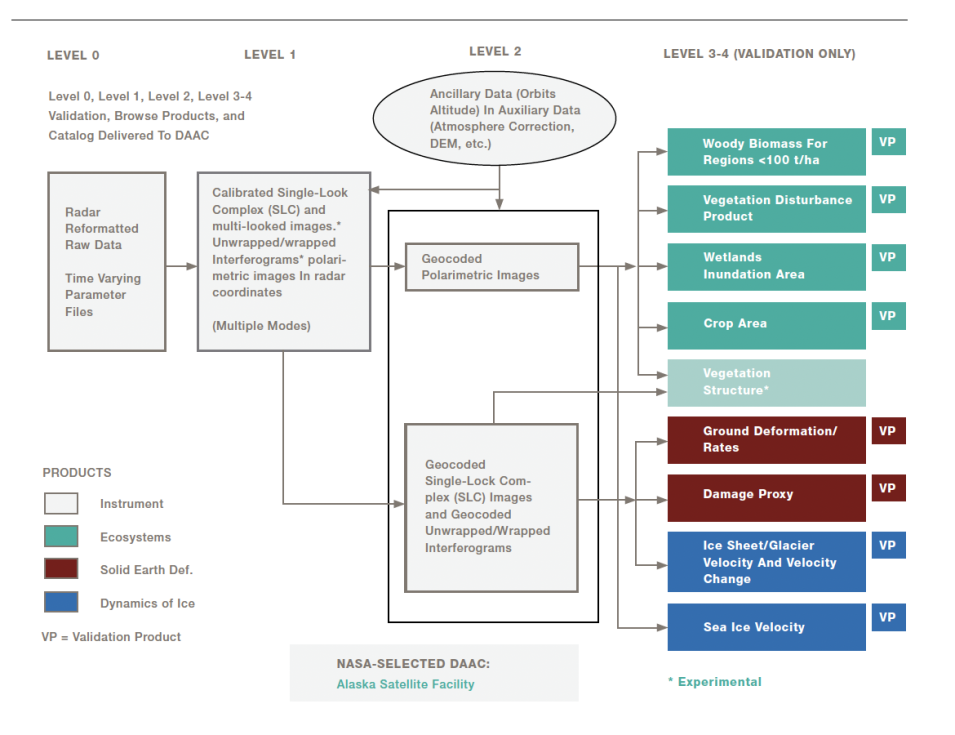
When NISAR starts to produce science-quality data sometime in late October or early November, it will be archived in the Earthdata Cloud and distributed by NASA’s Alaska Satellite Facility Distributed Active Archive Center (ASF DAAC). Data generation is projected at nearly 85 terabytes per day. NASA’s Earth Science Data and Information System (ESDIS) has been preparing for this influx through the Getting Ready for NISAR (GRFN) initiative, which laid the groundwork for processing, archiving, and disseminating NISAR data using the commercial cloud.

L-band SAR data will be available as Level 0 – Level 3 products. Specifically, ASF DAAC will provide a product range from Level 0 unfocused raw SAR data (L0B RRSD) to Level 3 Global Soil Moisture Product (L3 SM). Products through Level 2 will be produced for the entire mission dataset, and products at higher levels will be produced by the NISAR science team for calibration and validation purposes. All NASA data are free and open to all users.

Image
Image Caption

The scope of NISAR data products distributed by NASA’s ASF DAAC. Credit: NISAR Mission Science Users' Handbook, August 2019, Version 1

The S-band SAR operates at a 12 cm wavelength and is designed for targeted sensing of light vegetation. Users can find more information about how to access these data on the Indian Space Science Data Center website.

Preparing for First Light

Users can get ready for first light by exploring pre-launch resources provided by ASF DAAC, including more than 20 tutorials for using NISAR sample data and a NISAR Early Adopters Workshop series. NASA teams are also working to ensure that NISAR metadata—the structured information that describes each dataset and makes it more discoverable—are compatible with existing standards and best practices.

Check back soon for more information and resources.

Details

Last Updated

Aug. 5, 2025

Published

Aug. 4, 2025

Data Center/Project

Alaska Satellite Facility DAAC (ASF DAAC)