Planetary Computer provides access to a multi-petabyte catalog of global environmental data presented in consistent, analysis-ready formats. Users can access a variety of data through application programming interfaces (APIs) and directly via Azure storage. This flexible scientific environment allows users to analyze the data as well as build applications to use on top of the platform.
Enhancing Land Monitoring Capabilities with High-Resolution Imagery
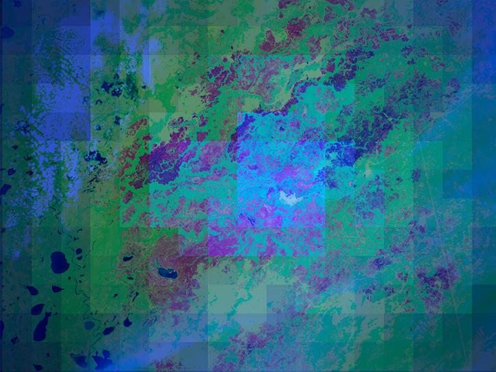
HLS provides a seamless set of surface reflectance records from the Operational Land Imager (OLI) aboard the NASA/USGS Landsat-8/9 and Multi-Spectral Instrument (MSI) aboard the European Space Agency's Sentinel-2A/B/C remote sensing satellites. By harmonizing these datasets, NASA provides a continuous, high-resolution view of our planet, which allows for better analysis of land use changes, vegetation health, water resources, and more.
The HLS project was created in response to the needs of the U.S. Federal Government identified by the Satellite Needs Working Group (SNWG) biennial survey. In that assessment, federal agencies and end users identified a need for more frequent Landsat-like observations to track short-term changes in vegetation and other land components to support agricultural monitoring and land cover classification at moderate to high resolution in both the visible and thermal components of the electromagnetic spectrum.
The project's data products, which are distributed by NASA's Land Processes Distributed Active Archive Center (LP DAAC), greatly improve current publicly available remote sensing land monitoring capabilities, particularly in terms of the frequency of land surface observations through time. The harmonization of HLS ensures that the Landsat 8 and Landsat 9 collection (30-meter spatial resolution with a 16-day repeat period) and the Sentinel-2A/B/C collection (10 to 20-meter spatial resolution with a five-day repeat period) can be used as if they were a single collection.
Through HLS, land surface observations can be acquired at an unprecedented 30-meter spatial resolution every two to three days. These frequent revisit times allow for time series imagery of land surface applications at the field/plot scale, which supports a wide range of applications including agricultural health, insect infestations, and natural hazard impacts.
HLS’s harmonizing algorithm was developed by the HLS Science Team and is ported and operated by the Interagency Implementation and Advanced Concepts Team (IMPACT) located at NASA's Marshall Space Flight Center in Huntsville, Alabama. The data products are archived at and distributed by NASA's LP DAAC, which is a partnership between NASA and the U.S. Geological Survey (USGS). Coordination between these partners on the data life cycle ensures that HLS data are high-quality, freely available, and accessible to end users with low latency.
Innovation Across a Range of Applications
With HLS data hosted on Azure and available via Microsoft Planetary Computer, users can scale complex environmental computations and apply Microsoft’s AI and cloud-based analytics to drive innovation across a range of applications. For example, by combining HLS data with Azure artificial intelligence (AI), machine learning, and high-performance computing services, users can:
- Automate land cover classification and vegetation monitoring
- Detect changes in urban development and deforestation trends
- Develop AI models to predict environmental patterns
- Create interactive geospatial applications that simplify decision-making
Already, IMPACT and Microsoft have worked together to create a prototype NASA Earth Copilot, an AI-powered assistant that helps scientists and policymakers discover, interpret, and analyze geospatial data using natural language queries such as “What was the impact of Hurricane Ian in Sanibel Island?” or “How did the COVID-19 pandemic affect air quality in the U.S.?” AI will then retrieve relevant datasets, making the process seamless and intuitive.
These tools let researchers spend less time on data retrieval and more on analysis, enable educators to more easily engage students in Earth science, and help policymakers make more informed decisions on disaster preparedness, urban development, and hazard mitigation.
Get Started
To begin leveraging HLS data on the Microsoft Planetary Computer, visit the dataset’s landing page to learn more about integrating it with Azure’s AI, machine learning, and data analytics tools.
Microsoft and NASA also offer comprehensive training resources to help you make the most of these capabilities. Learn how to build AI-powered applications using Azure OpenAI, process geospatial data efficiently, and deploy scalable solutions in the cloud by accessing Microsoft Azure training materials and tutorials. (An Azure account is not required to access these tutorials.)
NASA and NASA-funded science teams can request an Azure subscription through NASA’s SMCE. Visit https://smce.nasa.gov/ for details.
Microsoft Azure Tutorials