Introduction
The dramatic loss of Arctic sea ice stands out as one of the clearest signals of a warming planet, with nearly 50% of ice extent lost over the past four decades. This ice is a critical component of the Earth’s climate system, so as it melts earlier in the summer and forms later in autumn, the expansion of the open-water (ice-free) season affects local ecosystems, global climate, and human activities such as commercial shipping and national defense. Understanding the processes that control when and where sea ice forms is becoming increasingly important to accurately predict the future of Arctic sea ice and its impacts.
Satellite data and ocean models are essential tools for researchers studying sea ice across the Arctic Ocean, particularly because much of it is extremely difficult to access for in situ measurements. Remotely sensed observations using passive microwave radiometers and laser altimeters are especially powerful to track changes in sea ice extent and thickness. However, satellite measurements of sea surface salinity (SSS) remain underutilized for sea ice predictions.
Using satellite and ocean model data to study links between ocean salinity and Arctic sea ice freeze-up
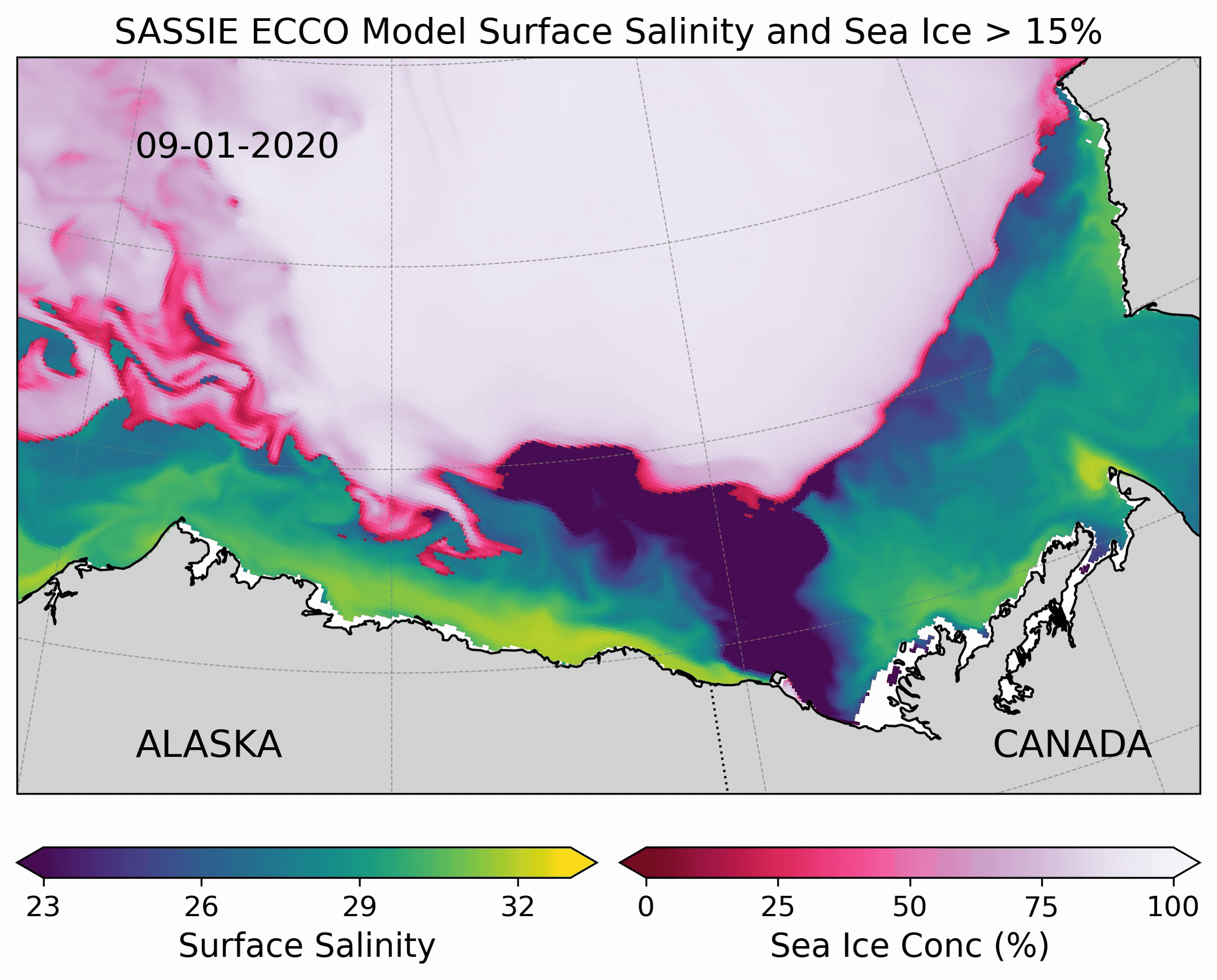
In 2022, NASA launched a field campaign in the Beaufort Sea, north of Alaska (Figure a), to study links between upper ocean salinity and fall sea ice formation. Researchers leading the Salinity and Stratification at the Sea Ice Edge (SASSIE) campaign hypothesized that sea surface salinity anomalies generated by summer sea ice melt are an important predictor for fall sea ice formation. In support of this program, a pan-Arctic coupled sea ice-ocean model was developed from the ECCO (Estimating the Circulation and Climate of the Ocean) project. Known as the SASSIE ECCO model, this seven-year simulation (2014-2020) is configured at a high resolution, with an average horizontal grid spacing of 3.5 km and 90 vertical levels.
While satellite data provide observations of Arctic sea ice concentration (SIC) and salinity at large spatial and temporal scales, ocean models enable researchers to investigate the ocean interior. Accordingly, the SASSIE ECCO model was used alongside remotely sensed observations of SIC and SSS to test the SASSIE hypothesis in the Beaufort Sea. This integrated approach provides a powerful framework to evaluate how ocean salinity influences the timing and extent of Arctic sea ice.
Major Findings
A recent study shows how freshwater discharge from the Mackenzie River helps sea ice form earlier in the eastern Beaufort Sea by increasing salinity stratification near the ocean surface. The Mackenzie River is the largest North American source of freshwater to the Arctic Ocean, and it strongly influences the structure of the upper ocean in this region.
In the Arctic Ocean, layering of the upper ocean is mainly controlled by salinity. As freshwater from the Mackenzie River spreads across the Beaufort Sea, it forms a lighter, fresher layer at the surface that floats on top of warmer, saltier water below. This layering — known as salinity stratification — acts like a barrier between the surface and deeper water. Because the fresh surface layer does not mix easily with the warmer water underneath, heat from below cannot reach the surface as efficiently. As a result, the surface cools faster, allowing sea ice to form earlier than in nearby areas with saltier, better-mixed water. The early ice that forms over the Mackenzie River plume creates an “ice bridge” connecting the coast to the offshore pack ice, with open water remaining to the east and west (Figure 2 c and g).
