We are in the process of migrating all NASA Earth science data sites into Earthdata from now until end of 2026. Not all NASA Earth science data and resources will appear here until then. Thank you for your patience as we make this transition.
Read about the Web Unification Project
MODIS Resources
Earthdata resources for users working with NASA’s Moderate Resolution Imaging Spectroradiometer (MODIS) data include tutorials and other learning resources, news announcements such as instrument updates and data releases, user guides and related documents, and frequently asked questions.
MODIS Learning Resources

MODIS data captured the extensive flooding of the Shire River in Malawi and Mozambique, caused by unusually heavy rains and a tropical cyclone.
Data in Action
Feb. 15, 2015
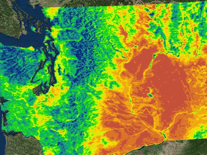
NASA's Northwest U.S. Agriculture Team used MODIS data to calculate the growing degree days of the codling moth.
Data in Action
Feb. 14, 2015

Learn how MODIS vegetation indices can be used to monitor variations in global vegetation conditions, such as seasonal leaf changes.
Data in Action
Dec. 23, 2014

Explore how LP DAAC data was used to forecast spring wheat yields in Canada, track elevation change at a U.S. coal mine, and examine land cover impacts on urban heat in Phoenix, Arizona.
Data in Action
Nov. 25, 2014

Learn how remote sensing data from space was used to detect and monitor the King Fire in California, showcasing the importance of satellite imagery in wildfire management.
Data in Action
Nov. 7, 2014

Explore how MODIS data supports research on tick-borne disease spread in Kansas, water stress in African rangelands, and long-term greenness trends in Alaska’s boreal ecosystems.
Data in Action
Oct. 28, 2014

Read highlights from the Spring/Summer 20214 term of NASA's DEVELOP program.
Data in Action
Oct. 21, 2014

ASTER data are used to evaluate the affects of Hurricane Ivan, a unique and destructive storm, after making two U.S. landfalls.
Data in Action
Sept. 30, 2014
SHOWING 8 OF 222

Infrared data from NASA’s satellites and other sources offer researchers views of Earth’s hidden or obscured features and processes.
Feature Article
Sept. 26, 2022

There will be a data and imagery outage in GIBS and Worldview starting October 10, 2022. MOPITT NRT imagery will be unavailable starting October 3.
Blog
Sept. 22, 2022

The planned retirement of Terra and Aqua will have minimal impact on the continuity of the CERES long-term climate data record.
Feature Article
Sept. 21, 2022

Responding to this RFI by October 11 via NSPIRES is an opportunity for you to express your perspective on the value of continuing NASA Earth Observing System (EOS) observations, and the unique scientific contributions and applications that could result from continuing Terra, Aqua, and Aura observations through the next several years of orbital drift.
News
Sept. 15, 2022
SHOWING 4 OF 527
Frequently Asked Questions
Earthdata Forum
Our online forum provides a space for users to browse thousands of FAQs about research needs, data, and data applications. You can also submit new questions for our experts to answer.
Submit Questions to Earthdata Forumand View Expert Responses