We are in the process of migrating all NASA Earth science data sites into Earthdata from now until end of 2026. Not all NASA Earth science data and resources will appear here until then. Thank you for your patience as we make this transition.
Read about the Web Unification Project
MODIS Resources
Earthdata resources for users working with NASA’s Moderate Resolution Imaging Spectroradiometer (MODIS) data include tutorials and other learning resources, news announcements such as instrument updates and data releases, user guides and related documents, and frequently asked questions.
MODIS Learning Resources
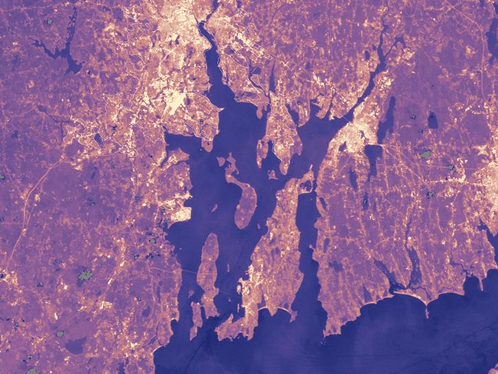
Population data from the Gridded Population of the World (GPW) project and land surface temperature data from MODIS show that higher UN-adjusted population density correlates with higher Urban Heat Island temperatures.
Data in Action
Aug. 4, 2017

Learn how to decode quality data from MODIS products using an API quality service.
Tutorial
July 28, 2017

This ARSET training provides an overview of drought classification and web-based tools for drought monitoring and visualization.
Training
July 12-19, 2017

This ARSET training covers how to access and apply satellite data relevant to land indicators, such as estimating total forest area and forest change.
Training
June 20-22, 2017

Read how Navajo Nation Climate III DEVELOP team used Earth observation data to investigate drivers of drought in the Southwestern United States.
Data in Action
June 14, 2017

Researchers use the the combined Terra and Aqua MODIS leaf area index data product to detect crop damage caused by hail.
Data in Action
May 31, 2017

Discover how remote sensing supports temperature modeling, urban agriculture mapping, and analysis of floodplain behavior in arid regions.
Data in Action
April 26, 2017

Learn how to access and use Moderate Resolution Imaging Spectroradiometer (MODIS) Vegetation Indices data.
Tutorial
April 10, 2017
SHOWING 8 OF 222

This dataset identifies cloudy and clear-sky scenes to ensure long term, reliable measurements of the Earth system.
News
Oct. 16, 2024

This new suite of products provides data on cloud properties for detecting climate trends and enhancing models.
News
Sept. 16, 2024

Join us to learn more about datasets and tools that enable the harmonization of remote sensing and in situ ecological data products for site-based research.
Webinar
Aug. 22, 2024

Geographer Veerachai Tanpipat promotes the use of NASA's Fire Information for Resource Management System (FIRMS) throughout the Lower Mekong River Region.
Feature Article
Aug. 20, 2024
SHOWING 4 OF 527
Frequently Asked Questions
Earthdata Forum
Our online forum provides a space for users to browse thousands of FAQs about research needs, data, and data applications. You can also submit new questions for our experts to answer.
Submit Questions to Earthdata Forumand View Expert Responses