We are in the process of migrating all NASA Earth science data sites into Earthdata from now until end of 2026. Not all NASA Earth science data and resources will appear here until then. Thank you for your patience as we make this transition.
Read about the Web Unification Project
Ground Water Data Access and Tools
NASA has ground water datasets that help researchers characterize the location and use of ground water . Access a range of data and data tools such as the GRACE(-FO) Data Analysis Tool, AppEEARS, and GRACE Python scripts to make the most of ground water data.
Ground Water Datasets
| Dataset Sort descending | Version | Platforms | Instruments | Temporal Extent | Spatial Extent | Spatial Resolution | Data Format |
|---|---|---|---|---|---|---|---|
| ABCFlux v2: Arctic-Boreal CO2 and CH4 In-situ Flux and Environmental Data | 1 | FIELD SURVEYS | SURVEYING TOOLS | 1984-05-01 to 2024-12-31 |
N: 82.8226 S: 43.323 E: 161.843 W: -165.833 |
CSV | |
| ABoVE: Monthly Hydrological Fluxes for Canada and Alaska, 1979-2018 | 1 | MODELS | Computer | 1979-01-01 to 2018-04-01 |
N: 83.125 S: 41.7508 E: -53.4255 W: -172.25 |
multiple | |
| BOREAS HYD-09 Streamflow Data | 1 | STREAMFLOW STATION | STREAM GAUGES | 1994-01-01 to 1996-12-31 |
N: 55.92 S: 53.86 E: -98.38 W: -104.82 |
ASCII | |
| BOREAS TF-11 CO2 and CH4 Flux Data from the SSA-Fen | 1 | FIELD INVESTIGATION, LABORATORY | STEEL MEASURING TAPE, GC-FID | 1994-06-08 to 1994-09-15 |
N: 53.8 S: 53.8 E: -104.62 W: -104.62 |
ASCII | |
| BOREAS TF-11 SSA Fen Soil Surface CO2 Flux Data | 1 | FIELD INVESTIGATION | LICOR GAS EXCHANGE SYSTEM, TEMPERATURE SENSORS, WATER LEVEL GAUGES | 1994-05-27 to 1995-10-03 |
N: 53.8 S: 53.8 E: -104.62 W: -104.62 |
ASCII | |
| BOREAS TGB-04 NSA-BVP Tower Flux and Meteorological Data | 1 | FIXED OBSERVATION STATIONS | LICOR QUANTUM SENSOR, ANEMOMETERS, THERMOCOUPLES, PSYCHROMETERS, PYRANOMETERS, ANEROID PRESSURE SENSOR, WATER LEVEL GAUGES, STREAM GAUGES, NET RADIOMETERS, IRGA, Bowen Ratio Devices | 1994-05-28 to 1994-09-17 |
N: 55.84 S: 55.84 E: -98.03 W: -98.03 |
ASCII | |
| ENVISAT MERIS Regional Binned Inland Waters (ILW) Data, version 5.0 | 5.0 | ENVISAT | MERIS | 2002-03-21 to 2012-05-09 |
N: 90 S: -90 E: 180 W: -180 |
netCDF-4 | |
| ENVISAT MERIS Regional Inland Waters (ILW) Data, version 5.0 | 5.0 | ENVISAT | MERIS | 2002-03-21 to 2012-05-09 |
N: 90 S: -90 E: 180 W: -180 |
netCDF-4 | |
| ENVISAT MERIS Regional Mapped Inland Waters (ILW) Data, version 5.0 | 5.0 | ENVISAT | MERIS | 2002-03-21 to 2012-05-09 |
N: 90 S: -90 E: 180 W: -180 |
netCDF-4 | |
| GLDAS Catchment Land Surface Model L4 daily 0.25 x 0.25 degree GRACE-DA1 V2.2 (GLDAS_CLSM025_DA1_D) at GES DISC | 2.2 | Catchment-LSM | NOT APPLICABLE | 2003-02-01 to Present |
N: 90 S: -60 E: 180 W: -180 |
SHOWING 10 OF 38
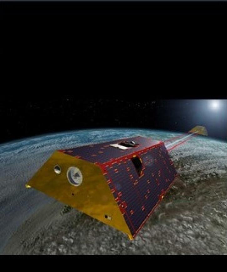
Featured Observation Method: GRACE
The NASA/German Space Agency (DLR) Gravity Recovery and Climate Experiment (GRACE) and GRACE Follow-on (GRACE-FO) platforms consists of two identical satellites that work together in orbit. The two satellites follow each other around the planet spaced 137 miles apart. Together hey measure differences in how Earth's gravity pulls on the satellites, which in turn can be used to reveal changes in the mass of water on and under the surface of Earth.
The GRACE satellites flew from March 2002 to October 2017 and GRACE–FO satellites have been in space since May 2018.
The GRACE satellites flew from March 2002 to October 2017 and GRACE–FO satellites have been in space since May 2018.
A team of NASA and university scientists has developed a new way to use measurements from NASA's GRACE mission to track changes in Atlantic Ocean currents.
1 MIN READ
Two datasets from the Gravity Recovery and Climate Experiment Follow-On (GRACE-FO) mission have just been released by NASA’s PO.DAAC.
2 MIN READ

Sentinel-1 synthetic aperture radar (SAR) data are used to create maps of surface water extent for research, planning, and disaster response.

Three new datasets show more than 17 years of variations in ice mass and ice mass changes from Antarctica and Greenland as well as global ocean mass change.
Frequently Asked Questions
Earthdata Forum
Our online forum provides a space for users to browse thousands of FAQs about research needs, data, and data applications. You can also submit new questions for our experts to answer.
Submit Questions to Earthdata Forumand View Expert Responses