We are in the process of migrating all NASA Earth science data sites into Earthdata from now until end of 2026. Not all NASA Earth science data and resources will appear here until then. Thank you for your patience as we make this transition.
Read about the Web Unification Project
Land Surface News
Articles, resources, and announcements from Land Surface.
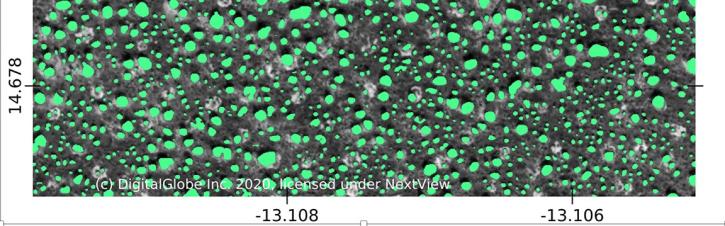
Using commercial satellite data and machine learning, scientists discovered a surprisingly large number of trees in Africa's drylands.
Feature Article
Nov. 19, 2020

NASA's SMAP team turns raw satellite data into more than a dozen data products for data users around the world.
Feature Article
Nov. 4, 2020

Colored bands in an interferogram show the gradual sinking of land (subsidence) in Arizona’s McMullen Valley Groundwater Basin between April 2010 and May 2015.
Feature Article
Nov. 4, 2020

Global composites of 30m resolution Landsat imagery available in Worldview
Feature Article
Nov. 4, 2020

Ground validation campaigns connect the dots between what is being remotely-sensed by a satellite instrument and ongoing Earth processes.
Feature Article
Nov. 4, 2020

The cryosphere expert and University of Colorado Distinguished Professor of Geography was the founding director of the National Snow and Ice Data Center (NSIDC).
Feature Article
Nov. 4, 2020

Since 1999, NASA’s Terra Earth observing satellite has completed more than 100,000 orbits. The instrument data from this workhorse satellite has resulted in one of the longest continuous data records of our planet ever recorded from space.
Feature Article
Nov. 4, 2020

The 16 datasets in the West Africa Coastal Vulnerability Mapping collection provide a wealth of information about the stresses affecting this important region.
Feature Article
Nov. 4, 2020
SHOWING 8 OF 285