We are in the process of migrating all NASA Earth science data sites into Earthdata from now until end of 2026. Not all NASA Earth science data and resources will appear here until then. Thank you for your patience as we make this transition.
Read about the Web Unification Project
Human Dimensions Learning Resources
Webinars, tutorials, data recipes and more to help you work with Human Dimensions.
Filters
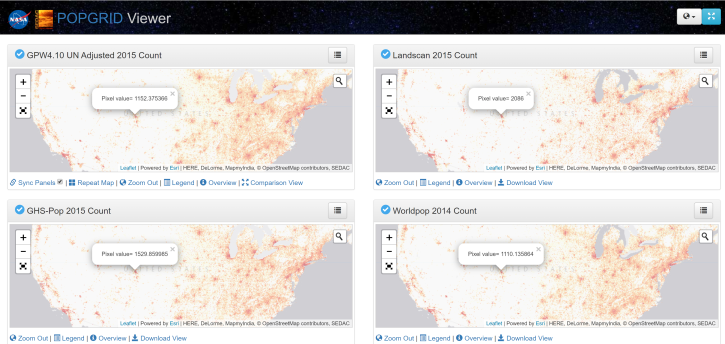
Join us for an introduction to gridded population and settlement data, an overview of gridding approaches and a demonstration on how to work with these data using SEDAC's POPGRID Viewer.
Webinar
Jan. 15, 2020

This ARSET training focuses on using interferometric synthetic aperture radar for characterizing landslides and generating a digital elevation model.
Training
Dec. 3-5, 2019
Esta capacitación de ARSET cubre el uso de SAR interferométrico para caracterizar deslizamientos y generar modelos de elevación digitales.
Training
Dec. 3-5, 2019

This ARSET training focuses on describing NASA digital elevation data and its application in deriving river basin information using HydroSHEDS.
Training
Nov. 26, 2019

This ARSET training introduces the applications of ECOSTRESS for crop health, volcanoes, urban heat, wildland fires, coastal systems, and much more.
Training
Nov. 20, 2019

Learn to use the Application for Extracting and Exploring Analysis Ready Samples (AppEEARS) tool with various fire, temperature, precipitation, and vegetation data.
Webinar
Oct. 25, 2019

This ARSET training guides participants through using Earth observations for habitat monitoring, specifically for freshwater fish and other species.
Training
Sept. 17 - Oct. 1, 2019

Esta capacitación de ARSET se enfoca en aplicaciones agrícolas y de inundaciones usando datos de radar de apertura sintética (SAR).
Training
Aug. 28 - Sept. 4, 2019
SHOWING 8 OF 317
Frequently Asked Questions
Earthdata Forum
Our online forum provides a space for users to browse thousands of FAQs about research needs, data, and data applications. You can also submit new questions for our experts to answer.
Submit Questions to Earthdata Forumand View Expert Responses