We are in the process of migrating all NASA Earth science data sites into Earthdata from now until end of 2026. Not all NASA Earth science data and resources will appear here until then. Thank you for your patience as we make this transition.
Read about the Web Unification Project
Human Dimensions Learning Resources
Webinars, tutorials, data recipes and more to help you work with Human Dimensions.
Filters

An introduction to GEDI Level 3 and Level 4 data products, learn how to discover, access, visualize, and analyze the data.
Webinar
June 9, 2022

This ARSET training focuses on introducing evapotranspiration (ET) products derived from remote sensing observations.
Training
June 1-15, 2022

This ARSET training provides an overview of atmospheric carbon dioxide measurements from space with the OCO-2 and OCO-3 satellite missions.
Training
May 24 - June 2, 2022
Esta capacitación de ARSET cubre mediciones de CO₂ atmosférico desde el espacio con las misiones OCO-2 y OCO-3.
Training
May 24 - June 2, 2022
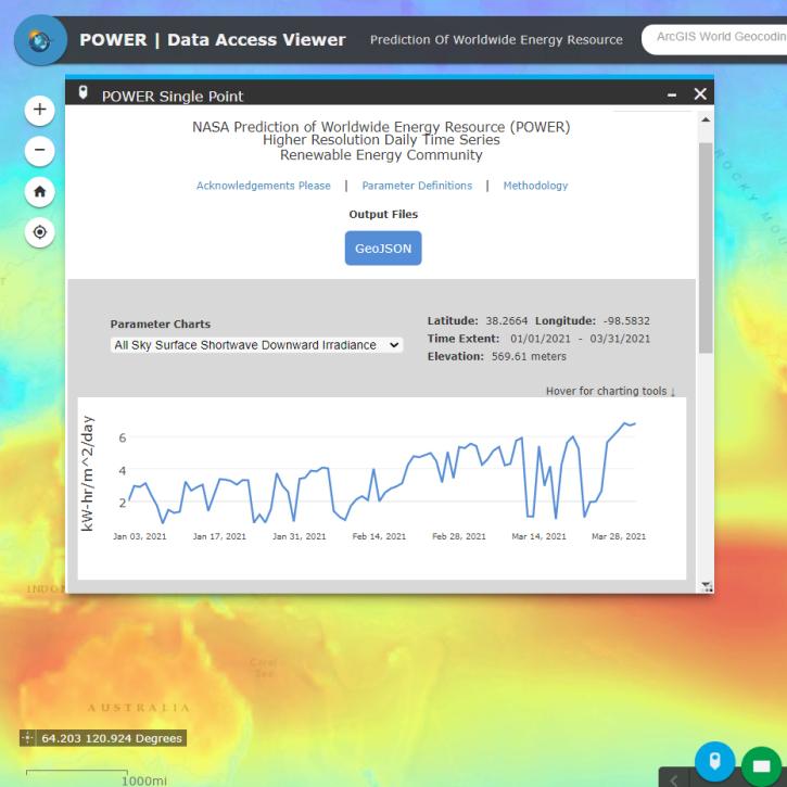
Join us for an introduction to NASA's POWER Project, its datasets and web services. In this webinar, we will highlight partnerships that facilitate the use of Earth observation data, and provide case studies of how POWER data are used within the renewable energy, agroclimatology and energy sustainability communities.
Webinar
May 18, 2022
Join us for an introduction to HLS data, services, and tools.
Webinar
May 18, 2022
Join us to explore cloud-based data discovery, access, visualization, and analysis services at NASA's Global Hydrometeorology Resource Center Distributed Active Archive Center.
Webinar
May 18, 2022

This ARSET training introduces bottom-up and top-down methods for tracking emissions and removals of carbon dioxide and methane from the atmosphere.
Training
May 11-25, 2022
SHOWING 8 OF 332
Frequently Asked Questions
Earthdata Forum
Our online forum provides a space for users to browse thousands of FAQs about research needs, data, and data applications. You can also submit new questions for our experts to answer.
Submit Questions to Earthdata Forumand View Expert Responses