Testing Tools to Gauge Snow Depth

A recent study examined the accuracy of satellite data for gauging snow depth. Researchers found that NASA's ICESat-2 can provide reliable estimates of snow depth.

Whether snow is abundant or scarce, scientists, civic leaders, and residents benefit from knowing the depth of snowpack. A recent study—led by NASA scientists and relying upon datasets available from the National Snow and Ice Data Center (NSIDC)—examined the accuracy of satellite data for gauging snow depth. Estimates of snow depth can be used to help derive snow water equivalent: namely, how much liquid water would result from all the snow melting. 

Unfortunately, gauging snow depth is complicated by varied terrain and vegetation. Snow can occupy relatively flat tundra with low-profile plants, deciduous forests on gentle hills, and conifer forests on rugged terrain. It may briefly cling to craggy peaks. Snow can fall at sea level and also a mile or more above it. 

Scientists cannot easily reach every place where snow settles, much less take continuous measurements of the entirety of snow cover across the country and the planet. Airborne surveys have occurred for decades, but only in select areas. 
Image
Image Caption

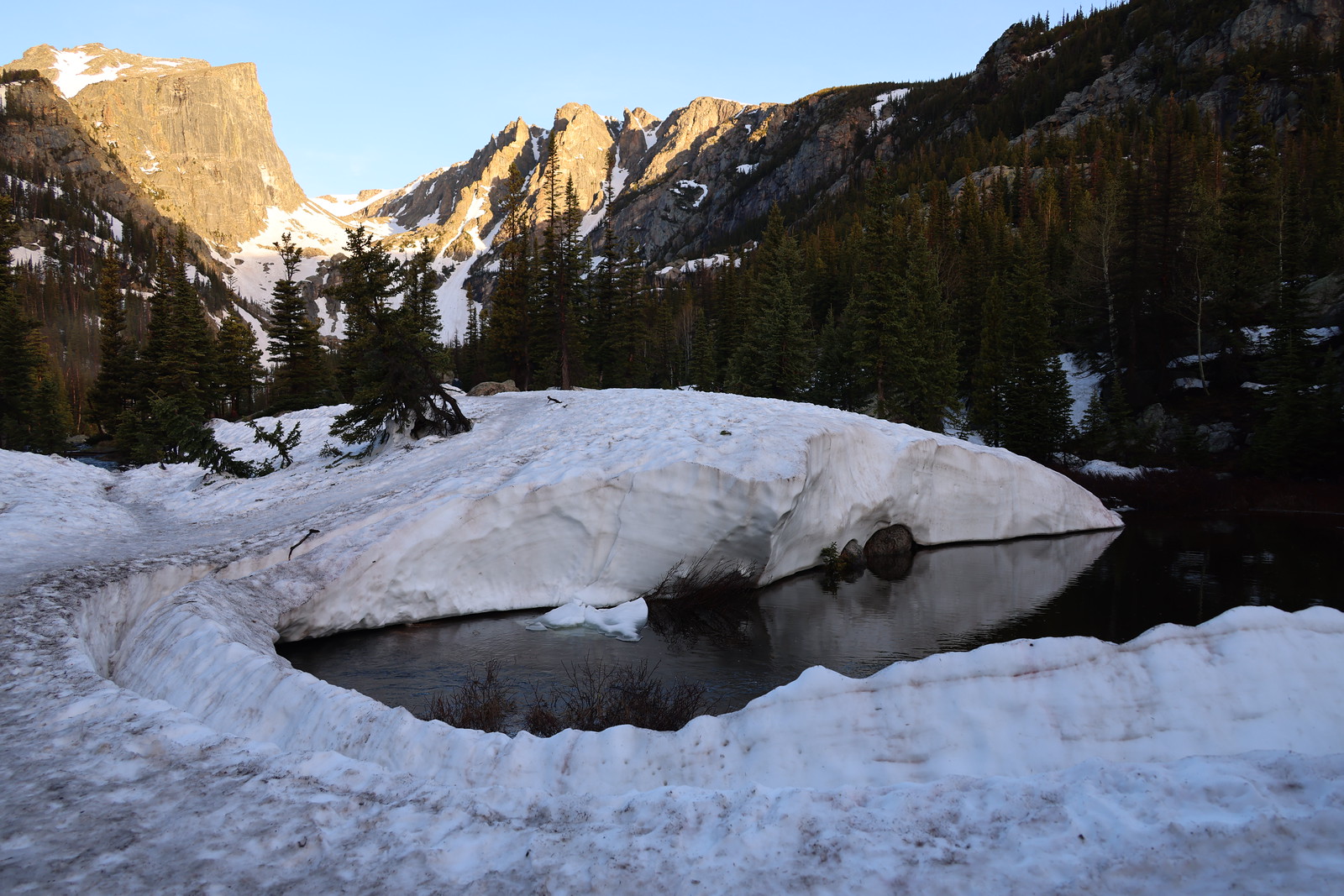
Snowpack accumulates in varied terrain. In the Rocky Mountains of western North America, snow can linger into the summer months under the right conditions. This photo, captured in June 2003, shows snowpack hanging on in Rocky Mountain National Park. Creative commons license by Flickr user Corey Seeman

To address these challenges, Xiaomei Lu of NASA Langley Research Center, Zachary Fair of NASA Goddard Space Flight Center and the University of Maryland, and four other scientists examined how accurately NASA’s Ice, Cloud and land Elevation Satellite-2 (ICESat-2) can assess snow depth. The study combined datasets from the Advanced Topographic Laser Altimeter System (ATLAS) instrument aboard ICESat-2 and from NASA’s SnowEx campaign. 

Monitoring snow cover matters on a local and global scale. “Where I live in the Washington, DC, area, we need to monitor snow for transportation and possible damage to appliances. The ‘snowcrete’ situation from the winter of 2026 was a great example,” Fair said. Snow presents similar challenges elsewhere but also brings significant benefits. He added: “Places like California or Colorado get a lot of water from snow, so snow depth and snow water equivalent are very important”—a reality underscored in 2026 by a snow drought.

Image
Image Caption

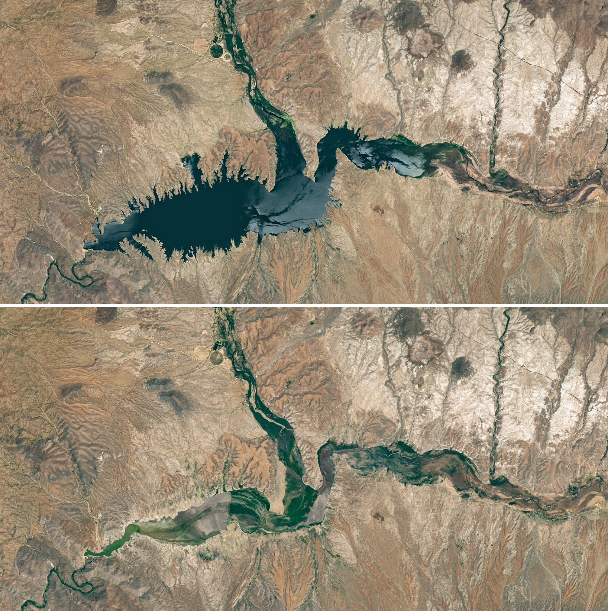
The snow-fed Gila River delivers water to Arizona’s San Carlos Reservoir (lower left quadrant of each image). Landsat captured images of the reservoir on June 7, 2023 (top) and May 22, 2026 (bottom). Poor snowfall in 2026 left the reservoir at a fraction of its long-term median extent. Images courtesy NASA Earth Observatory

ICESat-2’s ATLAS instrument aims three pairs of laser beams at Earth’s surface, emitting 10,000 pulses per second, with 300 trillion photons per pulse. From the relentless blizzard of photons that travel through the atmosphere and bounce off the planet’s surface, roughly a dozen return to the sensor’s receiver. Measuring the time required for those photons to return renders a detailed profile of the elevations of ice, land, and water surfaces below.  

“ICESat-2 was originally designed for elevation measurements, particularly for ice sheets and sea ice,” explained Lu, “but its highly precise photon-counting lidar system has enabled many additional applications beyond its original mission goals. Snow depth estimation is one example of how innovative analysis techniques can extend the scientific value of satellite missions.” 

The NASA NSIDC Distributed Active Archive Center (DAAC) archives and distributes more than 30 data products derived from the ATLAS instrument. One product, ATLAS/ICESat-2 L2A Global Geolocated Photon Data (ATL03), provides every photon’s latitude, longitude, and elevation. ATL03 serves as the primary input for many other ATLAS other products, including ATLAS/ICESat-2 L3A Land Ice Height (ATL06) and ATLAS/ICESat-2 L3A Land and Vegetation Height (ATL08). ATL03 and the other datasets were instrumental in the 2026 study. 

Validating ICESat-2’s Accuracy 

To check ICESat-2 measurements in the rugged terrain of the western United States, the study authors turned to the NASA SnowEx mission, a multi-year, multi-site effort involving on-the-ground and aircraft-borne measurements of snow water content across different times and locations, such as Colorado’s Grand Mesa and the Arctic Coastal Plain of Alaska. 

In the 2026 study, the authors cross-validated ICESat-2 measurements with those of SnowEx. The study team examined two methods of ICESat-2 snow depth measurement: pathlength and snow-on-off. 

Image
Image Caption

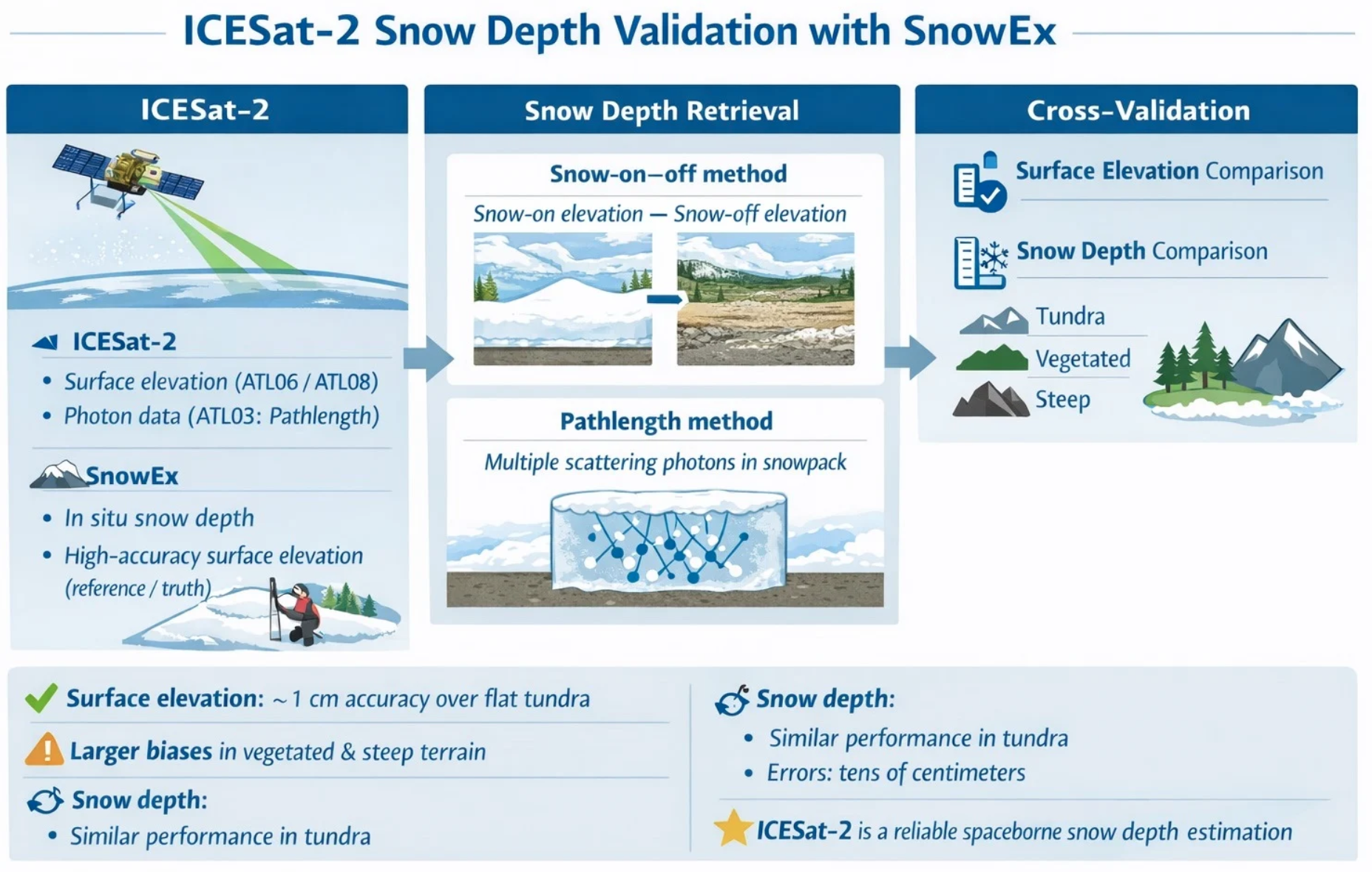
This graphic from Lu et al. 2026 gives an overview of the study method and findings. The authors employed both ICESat-2 and SnowEx observations to compare snow-on-off and pathlength approaches. Image from ICESat-2 and SnowEx Surface Elevation Measurements: A Cross-Validation Study for Snow Depth Application

“The pathlength approach is based on the multiple scattering of laser photons within the snowpack,” Lu explained. “As photons penetrate the snow, they scatter many times before returning to the satellite. Because photons travel farther within snow due to multiple scattering, the resulting travel time can be related to snow depth.” 

The snow-on-off method compares the surface elevation of a patch of land during snow-covered and snow-free times. Like the pathlength method, the snow-on-off method achieves an accuracy that can be measured in centimeters.  

However, ICESat-2’s measurements are limited to a narrow track, and it takes the satellite sensor 91 days to repeat an observation at the same reference ground track. The exact location of that ground track also can vary by as much as 10 kilometers (6 miles) between repeat observations. That means measurements of the same spot in snow-covered and snow-free conditions can be limited and might not be available at all. 

Lu, Fair, and colleagues compared the results of both satellite methods to onsite measurements acquired through the SnowEx23 field campaign, using measurements taken in spring 2022 and spring 2023 at multiple field sites in Alaska. 

They found that ICESat-2 accuracy depended on the terrain. The snow-on-off method achieved centimeter-level accuracy over flat terrain with little vegetation, but over more densely vegetated areas or steep terrain, that method proved less accurate. The pathlength method provided centimeter-level accuracy over flat tundra and also over forested and rugged terrain.  

When both terrain and method used are taken into consideration, the 2026 study found that ICESat-2 can reliably estimate snow depth from space. 

Lu intends to pursue remaining questions, such as how well ICESat-2 estimates snow depth in varying conditions of vegetation, terrain, and snow cover, and how atmospheric conditions can affect ICESat-2's photon counts. She is curious about reducing uncertainties in ICESat-2 retrievals, and in combining the satellite's observations with those of other satellites and airborne surveys, as well as with models. She also plans to combine data from ICESat-2, SnowEx, and NASA’s Operation IceBridge

Resources at NSIDC 

NASA’s NSIDC DAAC manages, distributes, and supports a variety of cryospheric and climate-related datasets as one of the discipline-specific Earth Science Data and Information System (ESDIS) data centers within NASA's Earth Science Data Systems (ESDS) Program. User Resources include data documentation, help articles, data tools, training, and on-demand user support. Learn more about NSIDC DAAC services.  

The NSIDC DAAC co-hosted a NASA webinar on April 29, 2026, highlighting this research. Titled Laser Altimetry Applications for a Changing World: Measuring Snow Depth with ICESat-2, the webinar featured Lu and Fair, NASA representatives, and NSIDC User Services specialist Mikala Beig. Beig and NSIDC have assisted with a series of data-use webinars and training sessions focused on helping users work with NASA products. 

Image
Image Caption

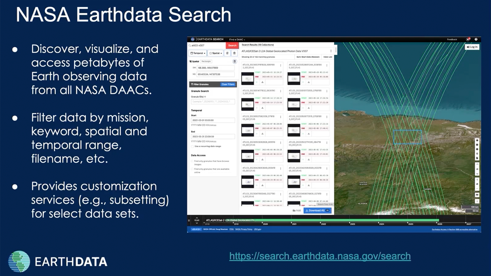
The NASA Earthdata webinar, presented April 29, 2026, included presentations by study authors and NASA-funded data experts. NSIDC’s Mikala Beig showed the process of finding and downloading ICESat-2 data.

NASA NSIDC DAAC data in this article: 

Larsen, C. (2024). SnowEx23 Airborne Lidar-Derived 0.5M Snow Depth and Canopy Height. (SNEX23_Lidar, Version 1). [Data Set]. Boulder, Colorado USA. NASA National Snow and Ice Data Center Distributed Active Archive Center. doi:10.5067/BV4D8RRU1H7U  

Smith, B., Adusumilli, S., Csathó, B. M., Felikson, D., Fricker, H. A., Gardner, A. S., Holschuh, N., Lee, J., Nilsson, J., Paolo, F., Siegfried, M. R., Sutterley, T. & the ICESat-2 Science Team. (2025). ATLAS/ICESat-2 L3A Land Ice Height. (ATL06, Version 7). [Data Set]. Boulder, Colorado USA. NASA National Snow and Ice Data Center Distributed Active Archive Center. doi:10.5067/ATLAS/ATL06.007 

Neuenschwander, A. L., Pitts, K. L., Jelley, B. P., Robbins, J., Markel, J., Popescu, S. C., Nelson, R. F., Harding, D., Pederson, D., Klotz, B. & Sheridan, R. (2025). ATLAS/ICESat-2 L3A Land and Vegetation Height. (ATL08, Version 7). [Data Set]. Boulder, Colorado USA. NASA National Snow and Ice Data Center Distributed Active Archive Center. doi:10.5067/ATLAS/ATL08.007 

Stuefer, S., May, L., Bailey, J., Vas, D., Mason, M., Hale, K., Marshall, H., Vuyovich, C. M., Elder, K. & the SnowEx Alaska March 2023 Team. (2024). SnowEx23 Mar23 IOP Community Snow Depth Measurements. (SNEX23_MAR23_SD, Version 1). [Data Set]. Boulder, Colorado USA. NASA National Snow and Ice Data Center Distributed Active Archive Center. doi:10.5067/6QD3UJVABY6D 

Reference 

Lu, X., Hu, Y., Kurtz, N., Omar, A., Knepp, T., & Fair, Z. (2026). ICESat-2 and SnowEx Surface Elevation Measurements: A Cross-Validation Study for Snow Depth Application. Remote Sensing, 18(2), 359. doi:10.3390/rs18020359 

Details

Last Updated

July 20, 2026

Published

July 20, 2026

Data Center/Project

National Snow and Ice Data Center DAAC (NSIDC DAAC)